Denver-based meteorologist Chris Tomer is one of the most accurate forecasters we know. Check out and subscribe to his mountain weather forecast videos to see where North America will get the most snow.
“Two additional storm systems through 2/9. High elevation rain/snow line 2/4 (with warm temps) then colder air gradually filters in forcing the rain/snow line to drop to lower elevations.
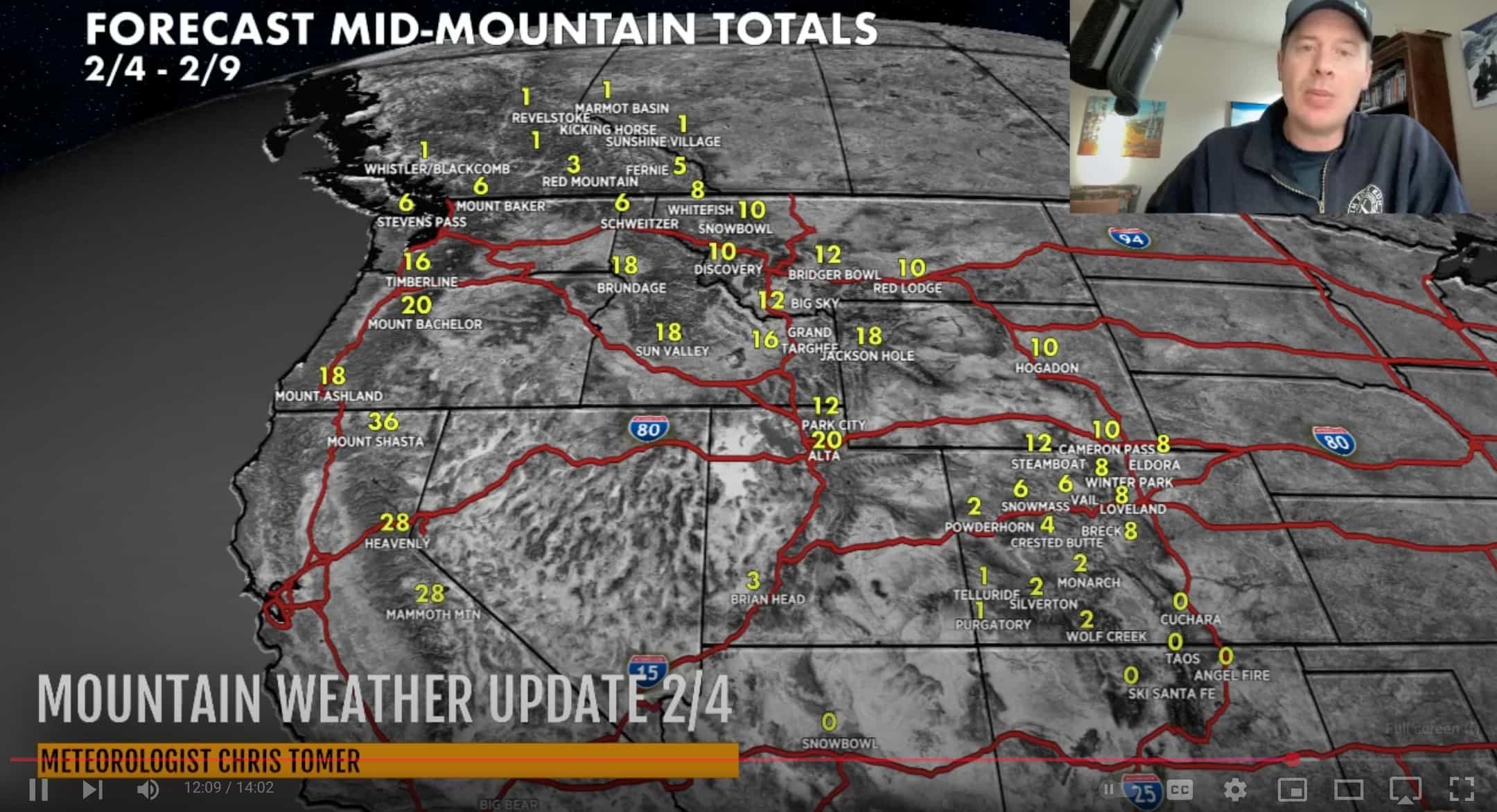
Snow Timeline:
Big Sky: 2/4(L), 2/5(H), 2/7(M)
Wasatch: PM 2/4(L), 2/5(H), 2/7(H)
Tetons: 2/5(H), 2/7(H)
Colorado: PM 2/5(L), PM 2/7-2/8(M/H), 2/10(L/M)
Interior BC: 2/9-2/10(L)
PNW: 2/4(L), 2/5(L/M), 2/10(H)
Tahoe: 2/4(H), 2/6(H)
Northeast: 2/6(M/H), PM 2/8-2/9(M/H)”
Here are the main highlights from the forecast, but please check out the full video for a detailed forecast, more resort totals, and support for Chris Tomer.
Tahoe and Sierra Nevada
The Pineapple Express has brought warm, moist air to the region, resulting in a high rain-snow line. Snow is falling above 8,000 feet, with rain or a mix below. Temperatures at lower elevations are between 20-32°F, causing wet conditions. The rain-snow line will drop in the coming days, bringing better snow accumulation to lower elevations.
Other Western Regions
Light snow is falling in Montana, Idaho, Oregon, and the Pacific Northwest. Wyoming sees light snow over the Tetons, Yellowstone, and Big Sky areas. Seattle experienced a rare snow advisory, with 1-2 inches of accumulation possible at sea level.
Upcoming Storm Systems
Two additional storm systems are forecast for much of the Western U.S. These will bring progressively colder air, lowering snow levels and improving snow quality at many resorts. Due to the colder temperatures, the second storm is expected to be the better producer.
Regional Forecasts
- Utah (Wasatch Range): There will be light snow today and heavy snow on the 25th and 27th. Temperatures will drop significantly by Friday, improving snow conditions.
- Wyoming (Tetons): Warm today, cooling down Wednesday through Friday. Two storm systems are expected, with the second likely bringing more significant snowfall.
- Colorado: Light snow on the afternoon of the 25th, moderate to heavy on the 27th-28th, and light to moderate on the 10th. Central and Northern mountains are expected to receive the most accumulation.
- Sierra Nevada: Heavy snow today and again on the 26th. The second storm will likely produce better quality snow due to colder temperatures.
- Northeast: Multiple chances for moderate to heavy snow accumulation over the next week.
Snow Accumulation Forecasts
- Wasatch Range: 12″-20″
- Tetons: 10″-20″
- Colorado (Central to Northern mountains): 6″-12″
- Sierra Nevada: Two rounds of heavy snow, totals not specified
- Idaho (Sun Valley area): 12″-18″
- Northeast (Vermont, New Hampshire, Maine): 10″-14″
Final Notes
The weather pattern remains active, with the potential for more storms beyond the current forecast period. Due to the new snow accumulation, skiers and snowboarders should be cautious about avalanche warnings in many areas.