Denver-based meteorologist Chris Tomer is one of the most accurate forecasters we know. Check out and subscribe to his mountain weather forecast videos to see where North America will get the most snow.
“High elevation rain/snow lines next two days then colder. Two additional storm systems gradually deliver colder air and additional snow accumulation to CA/ID/UT/WY/MT/CO.
Snow Timeline:
Big Sky: AM 2/3(H), 2/5(H), 2/7(M)
Wasatch: 2/5(H), 2/7(H)
Tetons: AM 2/3(H), 2/5(H), 2/7(H)
Colorado: 2/5(L), PM 2/7-2/8(M/H), 2/10(L)
Interior BC: 2/3(L)
PNW: 2/3-2/5(L),
Tahoe: 2/4(H), 2/6(H)
Northeast: PM 2/3(M), 2/6(M), 2/8-2/9(M/H)”
Here are the main highlights from the forecast, but please check out the full video for a detailed forecast, more resort totals, and support for Chris Tomer.
Atmospheric River Brings Heavy Snow and Warm Temperatures
A powerful Pineapple Express affects the Western United States, bringing significant snowfall to higher elevations and unusually warm temperatures. This atmospheric river focuses on Northern California, Southern Oregon, Idaho, and parts of Wyoming and Montana. Jackson Hole, Wyoming, has received 15 inches of snow in the last 24 hours, with more expected.
Temperature Anomalies and Rain-Snow Lines
The warm air mass associated with this system is causing high rain-snow lines across the region. In Jackson Hole, while the summit of Rendezvous Mountain is at 24°F, the base is experiencing temperatures of 34°F. Similar conditions are reported in Park City and Deer Valley, with rain at lower elevations. The rain-snow line will remain high for the next few days before colder air moves in.
Forecast for Key Ski Areas
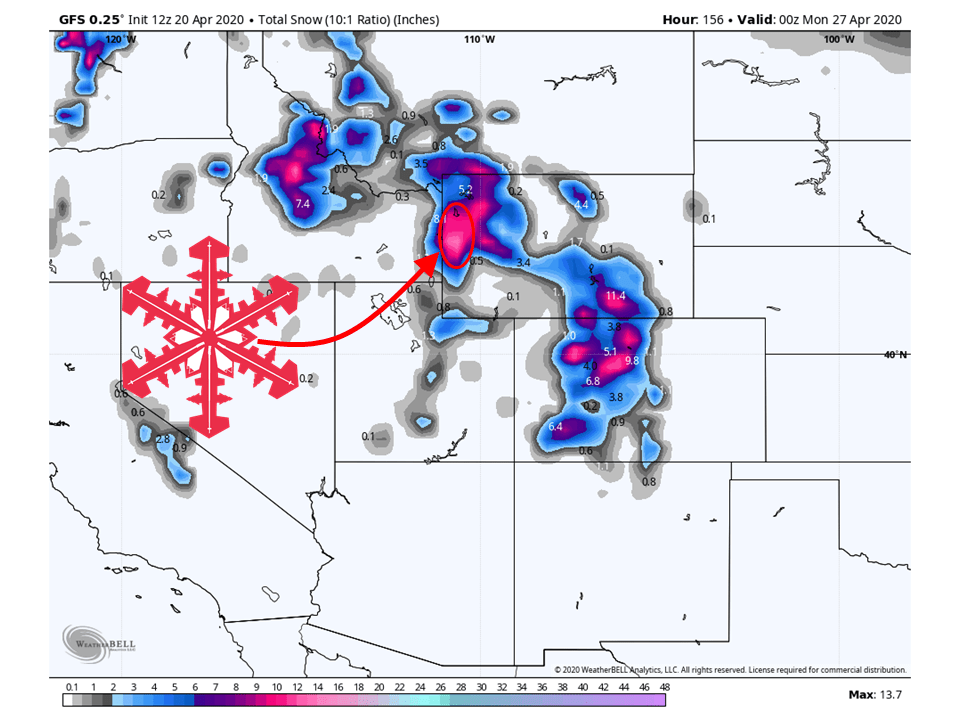
Two additional storm systems are expected to bring 12-20 inches of snow to the Wasatch Range in Utah between now and February 9. However, the freezing level will be around 11,000 feet for the next two days, dropping to 8,000 feet by February 5-6 and potentially down to 4,000 feet by February 7.
In Wyoming’s Teton Range, more snow is forecast for the coming days. After a brief break, the next storm system is expected to bring over a foot of additional accumulation around February 5, with temperatures gradually cooling.
Colorado ski resorts will have to wait longer for significant snowfall. The forecast indicates mostly light snow until late, around February 27-28, and again on February 10.
Sierra Nevada and Pacific Northwest
The Sierra Nevada, including Tahoe and Mammoth, is expected to receive 2-3 feet of accumulation as colder air moves in, improving snow production. In the Pacific Northwest, lighter accumulations are expected for most areas, with heavier snow focused on Mt. Bachelor, Mt. Ashland, and Mt. Shasta.
Northeast Outlook
Ski areas in the Northeast can expect a good stretch of weather with multiple storm systems. Vermont, New Hampshire, and Maine are forecast to receive 10-16 inches of accumulation, with slightly less in Massachusetts. Whiteface Mountain in New York is expected to get about 12 inches.