Denver-based meteorologist Chris Tomer is one of the most accurate forecasters we know. Check out and subscribe to his mountain weather forecast videos to see where North America will get the most snow.
“Feet of accumulation PNW/BC/ID/WY with pattern shift 1/31-2/5. Prior, a southern track low slides thorugh the 4-Corners 1/28-1/29 with snow accumulation for AZ/Southern UT/Southern CO/NM.
Snow Timeline:
Big Sky: Late 1/31-2/1(L/M), 2/2-2/3(H)
Wasatch: 2/1-2/2(M/H)
Tetons: Late 1/31-2/3(H)
Colorado: Late 1/28-AM 1/30(L/M)
Interior BC: 1/30(L), 1/31(H), 2/1(L)
Tahoe: PM 1/31-2/1(M/H)
Northeast: 1/28(L), 1/29(L/M), 1/31(M/H), 2/2(L)”
Here are the main highlights from the forecast, but please check out the full video for a detailed forecast, more resort totals, and support for Chris Tomer.
Southern Utah and Arizona Snow Update
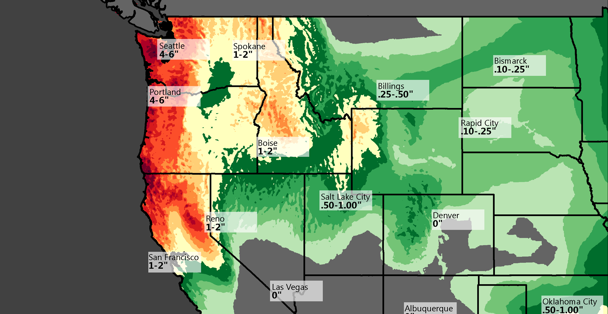
Snowfall is currently underway in southern Utah and parts of Arizona. Brian Head Ski Area in Utah is experiencing snow, with additional accumulation expected. Arizona Snowbowl has reported four inches in the past 24 hours, with more snow anticipated as the next wave progresses.
Four Corners and New Mexico Forecast
The low-pressure system affecting southern Utah will move eastward toward the Four Corners region. This will bring snow to New Mexico areas like Taos, Ski Santa Fe, and Angel Fire. Accumulations of around 10 inches are expected in these areas from January 29 to 30.
Northeast Snow Patterns
The Northeast is seeing a series of Clipper systems bringing light to moderate snow accumulations. A heavier snow event may occur later in the week, with accumulations ranging from 8 to 12 inches across Vermont and New Hampshire. Lake effect snow could bring up to 18 inches at Snow Ridge.
Upcoming Pattern Change for the West
A significant pattern shift is expected at the end of January into early February. This will bring heavy snowfall to the Pacific Northwest, interior British Columbia, Idaho, Wyoming, and the Tetons. Accumulations could reach several feet in these regions, with Jackson Hole forecasted to receive up to 30 inches.
Regional Snow Highlights
The Wasatch Range will see moderate to heavy snowfall starting February 1st or 2nd. Big Sky expects light to moderate snow in late January, with heavier accumulations by February 2nd. Interior BC resorts like Kicking Horse and Revelstoke could see a foot or more of snow by January 31.
Pacific Northwest and Sierra Nevada Outlook
The Pacific Northwest will experience heavy snowfall starting February 1. Resorts like Whistler, Mt. Baker, and Crystal Mountain could see 1 to 3 feet of snow. In California’s Sierra Nevada, snow levels will start high but drop later, with Mammoth Mountain accumulating significant snowfall by early February.
Colorado and Southern Rockies Forecast
Southern Colorado will see most of the state’s snowfall from this system. The San Juans could receive 4 to 8 inches, while areas like Cuchara and Angel Fire might see up to a foot of snow. Central and northern Colorado mountains are expected to see limited snowfall from this system.