This forecast was created at 10 a.m. PST on Monday, June 2, 2025.
The coming week drops two healthy waves across the Southern Alps, stacking up to four feet of early-season snow that will anchor the season’s base once the lifts crank up later this month. A dense opening blast Wednesday night cements the lower layers, while progressively colder, drier powder through the weekend tops the pack with light, fluffy insulation.
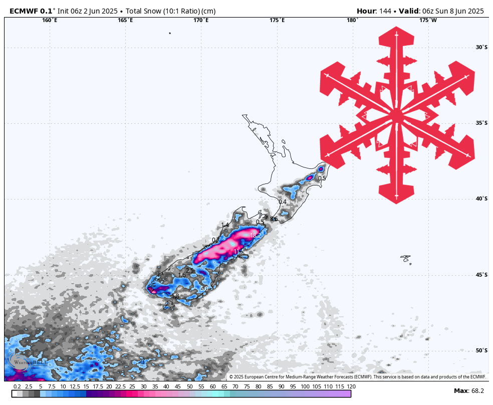
A compact southwest front rolls in Wednesday night, delivering the season’s first major snowmaker and laying down a bomber foundation. Snow levels hover near 3,500 feet—well below the Canterbury base areas—so every flake sticks. SLRs of 9-11:1 yield 8″-12″ of heavy cream at Mt Hutt, Porters, and Mount Dobson, perfect for bonding to the bare ground and filling early rocks. Gusty southerlies may drift upper slopes, but with no public operations yet, grooming crews will welcome the dense paste.
Late Thursday night a broad southerly trough settles in, firing convective bands through Monday and steadily deepening the snowpack. Cold air pours north, driving snow levels from 1,600 feet Friday to 700 feet Saturday—well below every base road—and boosting SLRs into the 15-17:1 range. Canterbury leads again: another 14″-30″ of light powder layers onto the existing slab, locking in a season-ready base of thirty-plus inches by Monday. Winds peak near 50 mph Friday night but drop each day, giving patrols a calmer window to assess coverage and avalanche hazard before opening preparations ramp up.
Queenstown / Wānaka fields sit on the southern fringe, but every inch counts when building that first metre of depth. Treble Cone, Cardrona, Remarkables, and Coronet Peak add a consolidated 5″-9″ over the period. Initial heavier snow Wednesday night plugs ground holes, while weekend blower at 15-16:1 blankets the slopes in silky topcoat—ideal material for cat-packing and winching once staff begin trail work.
Ruapehu scores a tidy refresher that will help lock in lingering winter patches on the volcanic hardpack. Tūroa and Whakapapa gain 6″-11″ Thursday night through Sunday night. Despite higher snow levels—fluctuating 2,600-5,000 feet—and frequent 60-mph gusts, this shot should stitch together the upper bowls, easing route work ahead of their later winter openings.
Resort-by-Resort Snowfall Totals
- Mt Hutt – 25″-42″ total (8″-12″ Wed night (06/04) – Thu night (06/05) + 17″-30″ Thu night (06/05) – Mon night (06/09))
- Porters – 22″-37″ total (8″-11″ Wed night (06/04) – Thu night (06/05) + 14″-26″ Thu night (06/05) – Mon night (06/09))
- Mount Dobson – 20″-33″ total (8″-12″ Wed (06/04) – Thu night (06/05) + 12″-21″ Thu night (06/05) – Mon night (06/09))
- Ohau – 12″-19″ Wed (06/04) – Sun night (06/08)
- Tūroa – 6″-11″ Thu night (06/05) – Mon night (06/09)
- Cardrona – 6″-9″ total (3″-4″ Wed (06/04) – Thu night (06/05) + 3″-5″ Fri (06/06) – Sun (06/08))
- Whakapapa – 5″-9″ Thu night (06/05) – Sun night (06/08)
- Remarkables – 4″-6″ total (3″-4″ Wed (06/04) – Thu night (06/05) + 1″-2″ Fri (06/06) – Sat (06/07))
- Treble Cone – 4″-6″ total (2″-3″ Wed night (06/04) – Thu night (06/05) + 1″-3″ Fri (06/06) – Sat night (06/07))
- Coronet Peak – 3″-5″ total (2″-2″ Wed night (06/04) – Thu night (06/05) + 1″-2″ Fri (06/06) – Sat night (06/07))