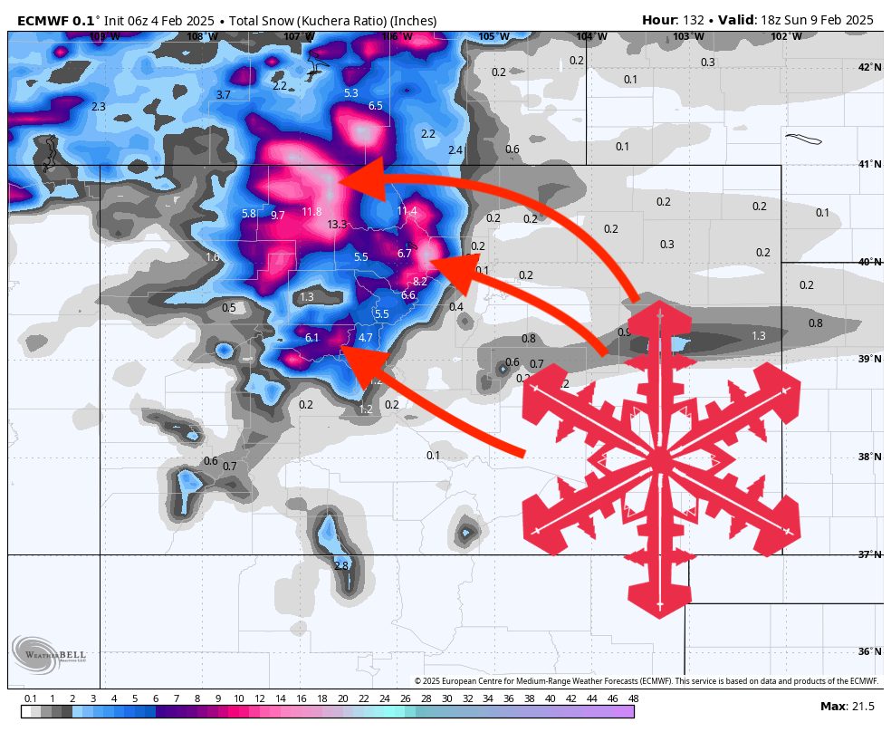
This forecast was created at 8:30 a.m. PST on Tuesday, February 4
A brisk midweek pattern brings light snow to the northern mountains of Colorado before a more potent storm arrives Friday night into Saturday. Colder air and increased snowfall will return by early next week. Expect a noteworthy shift toward winter conditions after a stretch of springlike warmth.
Warm and breezy conditions will dominate through midweek. Mild air remains in place through Wednesday, with above-average temperatures and only spotty light snow in the northern Colorado mountains—particularly around Wednesday—where a few inches of accumulation are possible. Snow levels remain pretty high midweek due to unseasonably warm daytime temperatures. Gusty west-to-southwest winds may affect upper elevations and ridgelines, but snowfall amounts from this midweek wave are expected to be modest overall, benefiting mainly the highest peaks.
The next significant surge arrives Friday night into Saturday. This cold front and associated energy will drop south from the northern Rockies, dropping temperatures notably across the state and producing heavier snowfall in the northern and central mountains. The northern ranges stand to pick up the highest accumulations—likely several inches—especially from late Friday into Saturday. Central mountain resorts can also expect moderate totals, though slightly lower than the northern peaks. Meanwhile, the southern mountains should see lighter snow overall, though some areas may still collect a quick burst of fresh accumulation.
Colder air and additional snow chances round out the period into early next week. By Monday, a reinforcing push of colder air may spread over the region, bringing another period of snowfall—mainly for the southern and eastern slopes. In the longer range, forecast guidance suggests below-normal temperatures could persist, with additional opportunities for snow beyond next Tuesday. This pattern change indicates a more active and wintry setup across much of Colorado.
7-Day Resort Forecast Totals
- Steamboat – 5”–10” total (1”–2” Wed (02/05)–Wed night (02/05) + 4”–8” Fri night (02/07)–Fri night (02/07))
- Winter Park – 3”–7” Fri night (02/07)–Sat night (02/08)
- Vail/Beaver Creek – 3”–6” Fri night (02/07)–Sat night (02/08)
- Snowmass – 2”–5” Fri night (02/07)–Sat night (02/08)
- Crested Butte – 2”–4” Fri night (02/07)–Sat night (02/08)
- Copper Mountain/Breckenridge – 2”–4” Fri night (02/07)–Sat night (02/08)
- Loveland/Arapahoe Basin – 1”–4” Fri night (02/07)–Fri night (02/07)
- Wolf Creek – 0–2” Mon night (02/10)–Mon night (02/10)
- Telluride – 0–2” Fri night (02/07)–Fri night (02/07)
- Monarch – 0–1” Fri night (02/07)–Fri night (02/07)