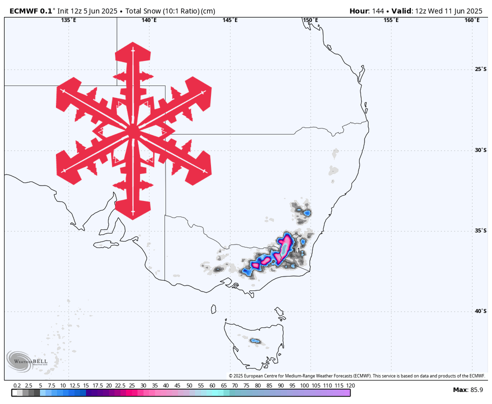
A vigorous northwest-flow storm drops into the Australian Alps Friday night, delivering wet, heavy snow at first, progressively colder powder by Sunday, and lighter wrap-around showers through Tuesday night. Weekend visitors will find lifts spinning at Thredbo, Perisher, Falls Creek, Mount Buller, Mount Hotham (from Sunday), and even tiny Mount Baw Baw, all of which should open with 6″-10″ already on the ground and double-digit totals piling up during the holiday weekend. What a way to start the season! Charlotte Pass and Selwyn Snowfields remain closed until June 21, but they will bank a healthy base from this storm for their delayed debut.
Friday night through Saturday launches the event as moist northwest winds crash into the ranges. Snow levels hover near 4,600 feet, so the initial 3″-6″ lays down a dense, wind-packed base at resorts opening this weekend. Gusts top 70 mph on exposed ridgelines at Buller, Falls, and Hotham, likely trimming lift ops, yet the fresh blanket will be welcome for limited first turns on Saturday. The same slushy, seven-to-one snow coats closed Selwyn and Charlotte Pass, helping their snowpack catch up.
Saturday night and Sunday bring the quality window. Colder air lowers snow levels to roughly 3,200 feet and pushes snow-to-liquid ratios into the eleven-to-thirteen-to-one range, switching the texture to soft, skiable powder. Resorts opening Saturday (Thredbo, Perisher, Falls Creek, and Buller) should nab another 4″-8″ of lighter fluff, while Hotham adds enough overnight to justify its Sunday start. Winds ease into the 20 mph bracket, making Sunday the best riding of the long weekend.
Monday and Tuesday wrap things up in a milder, showery pattern. A subtle southerly flow bumps snow levels back toward 5,000 feet, so lower lifts at Mount Baw Baw and Buller could see a brief rain-snow mix. Even so, upper slopes squeeze out 2″-5″ of thicker snow, topping most resorts in the high-teens to low-twenties for storm-total fluff. By Wednesday morning only scattered flakes linger, and winds relax.
Operational outlook: Thredbo, Perisher, Falls Creek, and Buller open Saturday, June 7; Hotham follows on Sunday, and Baw Baw aims for limited terrain Saturday as snowmaking continues. Charlotte Pass and Selwyn target June 21, using this storm to fortify their base. Plan your weekend around lower-wind Sunday turns, and expect rope-drops and terrain expansions each morning as patrols assess accumulating snow.
Resort-by-Resort Snowfall Totals
- Selwyn Snowfields – 15″-24″ Fri night (06/06)-Tue night (06/10)
- Falls Creek – 16″-23″ Fri night (06/06)-Tue night (06/10)
- Charlotte Pass – 15″-23″ Fri night (06/06)-Wed night (06/11)
- Thredbo – 14″-22″ Fri night (06/06)-Wed (06/11)
- Mount Buller – 13″-20″ Fri night (06/06)-Tue night (06/10)
- Perisher – 13″-20″ Fri night (06/06)-Wed (06/11)
- Mount Hotham – 13″-20″ Fri night (06/06)-Tue night (06/10)
- Mount Baw Baw – 6″-9″ Sat (06/07)-Tue night (06/10)