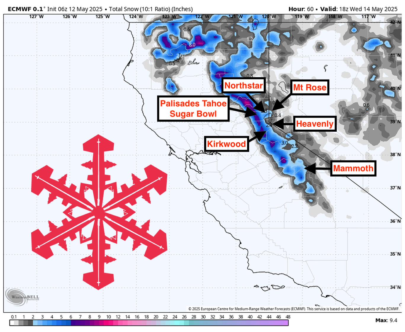
This forecast was created at 7:30 a.m. PST on Monday, May 12.
A late-season spring storm brushes the Sierra early in the week with modest, moderate-density snow before high pressure restores dry, warmer conditions through Friday and leaves only a slim chance of a weak follow-up system next weekend. Totals of roughly 4″-7″ around Tahoe and lighter amounts further south will refresh upper-elevation terrain Monday night into Tuesday, but the window for powder turns will close quickly as sunshine, rising freezing levels, and a classic freeze-thaw cycle dominate the latter half of the period.
From Monday to Tuesday, the Spring System brings the last meaningful snowfall to the Sierra. Showers break out before sunrise Monday, first in the Lassen region and then south into Tahoe as a compact trough crosses northern California. Snow levels start near 6,500-7,000 feet, so early precipitation is confined to the upper mountains. Ridge-top winds roar at 60-80 mph (locally reaching 90 mph on the highest crests), making exposed terrain feel wintry despite the mid-May timing. By late afternoon, colder air sinks in, lowering snow levels to around 5,500 feet and improving coverage. The Sugar Bowl and Palisades should pick up 3″-4″ by midnight, with snow-to-liquid ratios (SLRs) mostly 9-12:1, indicating fairly dense, “creamy” powder that will ski best on steeper pitches.
A colder Tuesday morning keeps light snow showers going and pushes flakes lower on the hill. Overnight cooling lowers snow levels to roughly 5,000 feet, allowing a final 1″-2″ of accumulation down to mid-mountain before moisture quickly tapers. SLRs on the backside of the system nudge to 11-13:1, so snow quality improves slightly—especially at Mammoth, which sees its biggest burst (about 2″) after dark Tuesday. Winds ease but remain breezy enough on the ridges to drift new snow into lee pockets that will ride soft at rope-drop. By midday, skies trend partly cloudy and temps stay several degrees below average, locking in the fresh surface for the first groom of the day.
Wednesday through Friday deliver classic spring skiing under building high pressure. Skies clear, winds relax, and temperatures return to seasonal norms, with highs in the upper 40s to low 50s at 8,000 feet and freezing levels rising above 9,000 feet each afternoon. Expect firm morning corduroy that loosens into forgiving corn by late morning. By mid-afternoon, south-facing slopes will turn slushy, while north aspects will preserve Monday-Tuesday’s modest refills under a surface crust. Overnight freezes look strong enough to regenerate corn for successive days, so timing laps to follow the sun will be the key to finding buttery turns.
Next weekend offers only a low-confidence chance at another light dusting. A weak wave skirts the Pacific Northwest Saturday night into Sunday and may toss a few showers onto the northern Sierra, but guidance keeps odds near 20 percent, and any snowfall would be insignificant—think a dusting to perhaps an inch above 8,000 feet with snow levels hovering near 7,500 feet. Beyond that, large-scale signals favor a generally dry pattern with near-normal temperatures into the middle of next week, so meaningful new snow looks unlikely after the early-week burst.
Resort Forecast Totals
- Palisades Tahoe – 4″-7″ Mon (05/12) – Tue night (05/13)
- Sugar Bowl – 4″-6″ Mon (05/12) – Tue night (05/13)
- Kirkwood – 2″-5″ total (1″-2″ Mon (05/12) – Tue (05/13) + 1″-3″ Tue (05/13) – Tue night (05/13))
- Mammoth – 2″-4″ Mon night (05/12) – Tue night (05/13)
- Mt Rose – 1″-3″ Tue (05/13) – Tue night (05/13)