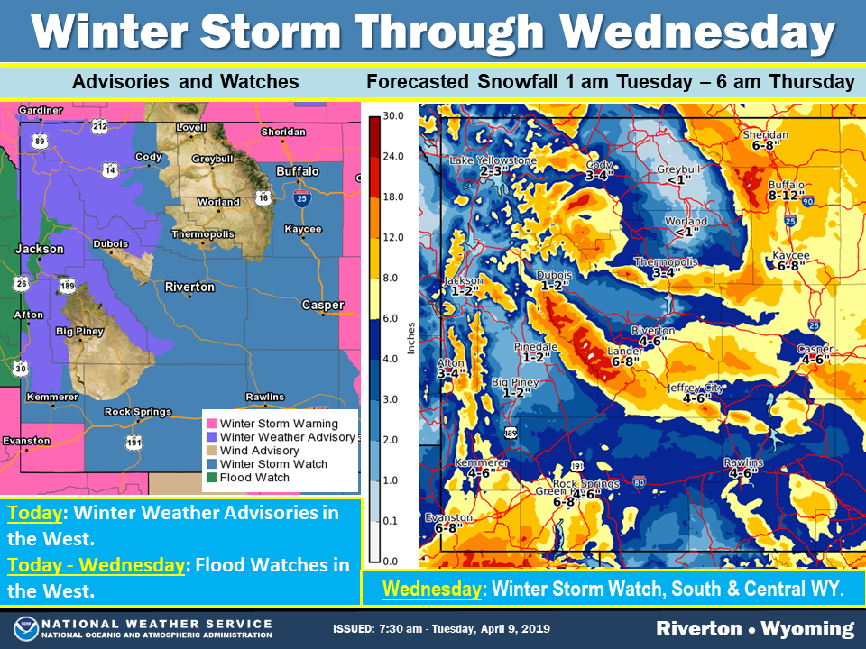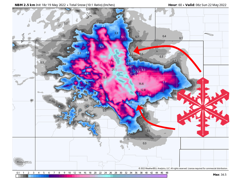
A potent early-season barrage dives into the Andes this weekend, dropping the deepest accumulations at Las Leñas and the high-elevation Chilean Three Valleys while spreading lighter refreshes north and south. A warm, wind-whipped opener tonight quickly cools, then a colder Saturday-night surge unloads more than a foot on the central spine. Snow levels hover near 8,000 feet for the Chilean giants but sit at or below the bases for Patagonia and Tierra del Fuego, so virtually every liftable acre gets coated. A weaker follow-up from Tuesday to Thursday sprinkles a few bonus inches on the Argentine side before skies calm.
Friday night brings the first wave, a moist northwest push that slams Corralco and Nevados de Chillán and spills east into Chapelco and Cerro Catedral. Temperatures hang in the lower 30s Fahrenheit at the Chilean bases, so early flakes come dense with meager five-to-eight-to-one ratios and snow levels flirting with 6,000 feet. By Saturday morning, colder air drops levels to roughly 3,500 feet, improving ratios into the low teens and delivering half-foot storm totals for the southern Lake District while winds gust past sixty miles per hour on the volcanoes.
The main event occurs from Saturday night through Sunday night, when a deeper trough taps colder mid-level air and draws moisture along the central Andes ridge. Portillo, Valle Nevado, La Parva, and El Colorado sit well above the eight-thousand-foot snow line and cash in on eight to near fifteen inches overnight Saturday, with another four to six Sunday under moderate ten-to-eleven-to-one ratios—respectable powder for May. Las Leñas grabs the jackpot as the jet streak noses farther south, piling roughly two feet of new snow by Monday morning. The wind remains manageable here, generally below thirty miles per hour.
Showery leftovers linger Monday while a secondary short-wave noses in Tuesday night, favoring the Argentine Lake District. Chapelco and Cerro Catedral can expect an additional two to five inches of snow, but with rising snow levels reaching four thousand feet, lower trails may experience brief mixed precipitation. Las Leñas adds a skiff, keeping surfaces fresh. Far south, Cerro Castor quietly stacks five to seven inches through Tuesday with ratios near ten-to-one and snow levels pinned near sea level—sneaky good turns there.
Overall quality trends from heavy cream to chalky powder as each pulse cools. Expect wetter, upside-down layers low on the volcanoes tonight, improving markedly by Saturday afternoon. Central Andes hitters stay all-snow thanks to their lofty elevations, though Monday warmth may crust the very lowest parking-lot approaches. Winds are expected to peak tonight in south-central Chile and then ease through the weekend.
Resort-By-Resort Snowfall Totals
- Las Leñas – 19”–29” Sat (05/17) – Wed night (05/21)
- Valle Nevado – 14”–22” Sat (05/17) – Mon night (05/19)
- El Colorado – 13”–21” Sat (05/17) – Tue (05/20)
- Portillo – 13”–20” Sat (05/17) – Mon (05/19)
- Nevados de Chillán – 13”–18” total (11”–14” Fri night (05/16) – Sat night (05/17) + 2”–4” Sun (05/18) – Mon (05/19))
- Cerro Catedral Alta Patagonia – 10”–16” total (7”–10” Fri night (05/16) – Mon night (05/19) + 3”–5” Tue night (05/20) – Thu (05/22))
- La Parva – 10”–15” Sat (05/17) – Mon (05/19)
- Chapelco – 9”–14” total (8”–10” Fri night (05/16) – Mon night (05/19) + 2”–4” Tue night (05/20) – Wed night (05/21))
- Corralco – 8”–11” Fri night (05/16) – Sun (05/18)
- Cerro Castor – 5”–7” Sat night (05/17) – Tue (05/20)