This forecast was created at noon PST on Saturday, April 26, 2025.
A potent late-season storm will spin snow back into the Northern Rockies Sunday night–Monday, delivering up to 9″ on the higher slopes of southwest Montana before a cooler, showery pattern lingers mid-week and high pressure brings a dry, springlike rebound to close the period. The setup favors the Bridgers, Gallatin, and Madison ranges for the best turns early in the week, while most other mountains see just a quick refresh before sunshine, rising freezing levels, and mild temperatures return by Thursday–Friday.
Warm, mostly dry weather rules the range through Saturday. Daytime highs will run 10 – 15 °F above average at ski elevations, and snow levels hold well above 8,000 feet across Montana and Wyoming. Scattered afternoon thunderstorms may pop over the Blue Mountains, Idaho Panhandle peaks, and high ridges of western Wyoming, but any graupel or wet flakes will melt quickly. Southwesterly ridge-top winds remain breezy yet well below chair-lift limits.
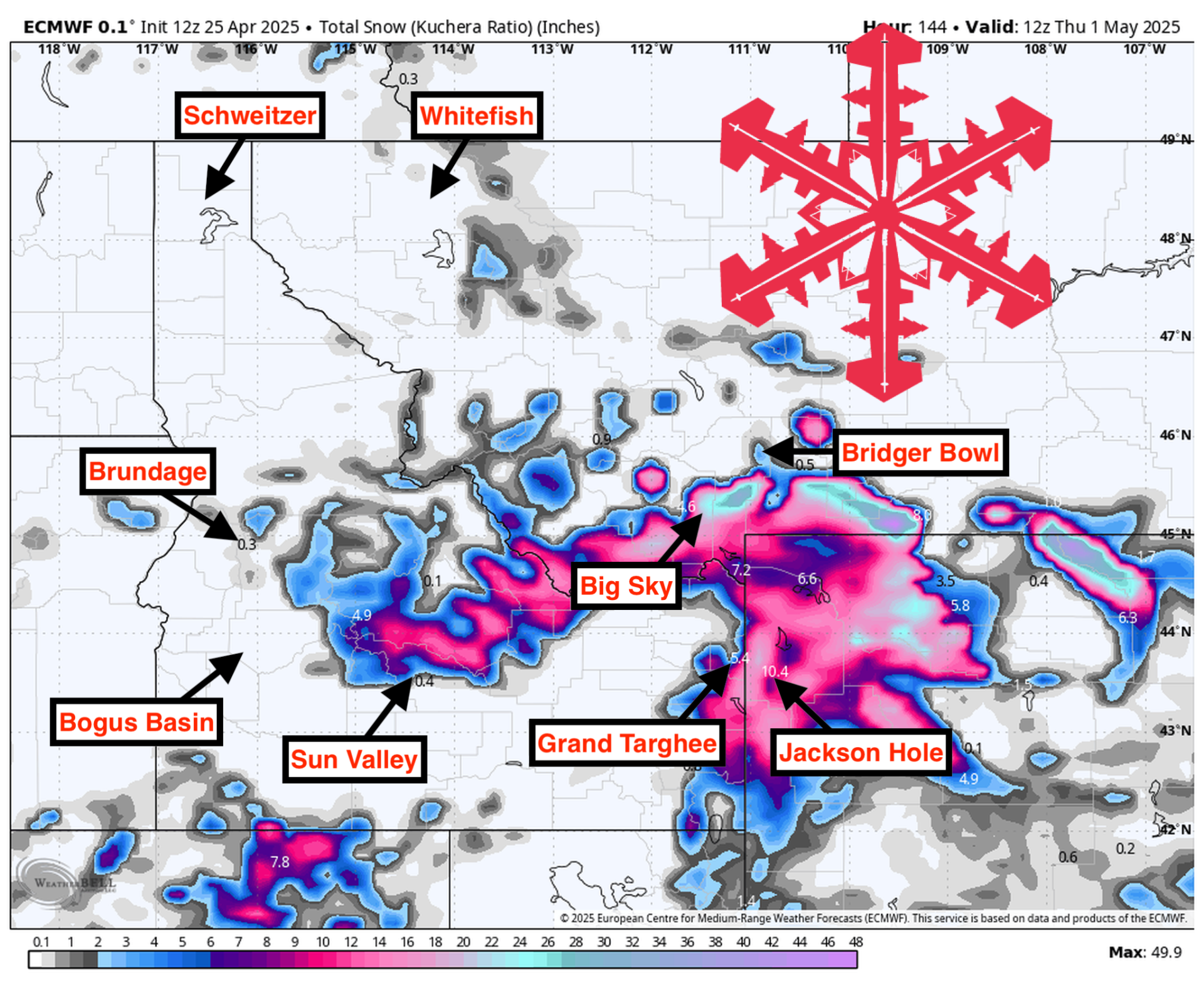
Sunday night–Monday’s closed low flips the switch back to winter for a quick hit of powder. Moisture funnels into southwest Montana first, then drapes southward across the Tetons overnight. Snow levels start around 7,500 – 8,500 feet but crash to 3,500 – 6,500 feet by dawn Monday as a sharp cold front moves through. Big Sky, the Bridgers, and the Tobacco Roots could squeeze out 5″-9″ with locally higher pockets, while Grand Targhee nabs 3″-6″ and Jackson Hole a lighter 1″-3″. Snow-liquid ratios will mostly fall in the 6-10:1 range—good enough for creamy turns but not true blower quality. Gusty west-northwest winds of 25-35 mph may briefly bump upper-mountain lift operations early Monday.
A weaker Tuesday shortwave maintains cool, unsettled conditions. Hit-or-miss showers redevelop from the Idaho Panhandle into the Gallatin and Absaroka ranges, with snow levels hovering near 6,000 feet. Additional accumulations look light—generally a trace to 2″—though convective bursts could lay down brief coatings of higher-density snow. Temperatures remain the coolest of the week, and ridgetop winds stay brisk at 20-30 mph.
Wednesday tapers, then high pressure restores spring skiing Thursday–Friday. Residual morning flurries clear quickly, giving way to strengthening sunshine and a steady warming trend. Freezing levels soar to 9,000 – 10,000 feet by late week, and winds ease below 15 mph. Looking beyond the seven-day window, ensemble guidance favors above-normal temperatures and below-normal precipitation for the northern Rockies through the May 2 – 8 timeframe, suggesting any fresh snow opportunities will be limited after Monday’s burst.
Resort Forecast Totals
- Big Sky – 5″–9” Sun night (04/27) – Mon night (04/28)
- Grand Targhee – 3″–6” Sun night (04/27) – Mon night (04/28)
- Bridger Bowl – 1″–3” Sun night (04/27) – Mon (04/28)
- Jackson Hole – 1″–3” Sun night (04/27) – Mon night (04/28)