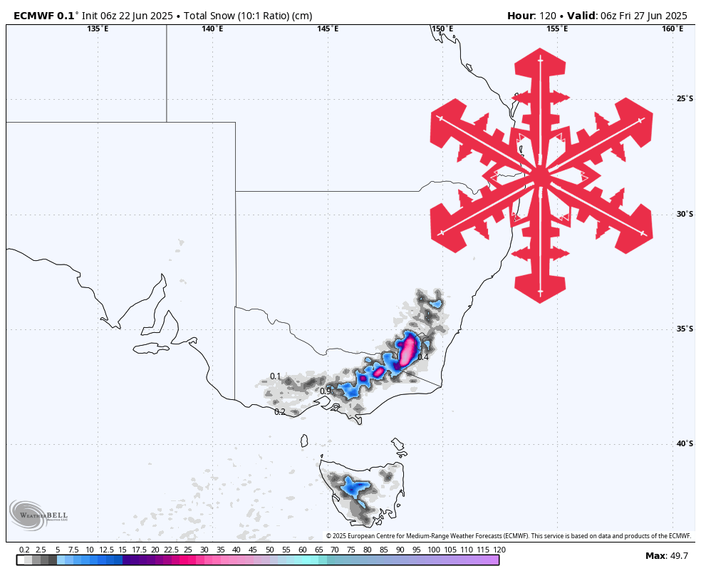
A prolonged early-season storm will sweep the Australian Alps from Monday night through Thursday, delivering roughly half a foot to more than a foot of new snow, with the deepest turns lining up for the higher peaks of New South Wales while Victoria scores respectable totals of its own. Snow quality starts heavy and wet but improves steadily as colder air pushes north, dropping snow levels toward 3,000 feet and boosting snow-to-liquid ratios into the low teens by Wednesday night.
Monday night into Tuesday opens the assault with a warm, moisture-rich northwest flow. Dense, cream-cheese snow falls as snow-to-liquid ratios languish between one and six to one and snow levels hover near 6,000 feet—right at or above many base areas. Expect sticky turns down low, wind gusts topping 80 miles per hour, and possible mixed precipitation below mid-mountain, especially at Falls Creek, Hotham, and the lower lifts of Perisher and Charlotte Pass.
By Tuesday night the cold front sweeps through, flipping the switch to more wintry conditions. Temperatures drop into the middle 20s, snow levels tumble toward 3,500 feet, and snow-to-liquid ratios jump to roughly seven to nine to one. This is the meat of the storm: widespread four-to-six-inch bursts push overnight totals past the half-foot mark at Perisher, Thredbo, Charlotte Pass, Falls Creek, and Hotham, while Selwyn Snowfields scores an outsized hit thanks to its northerly exposure.
Wednesday brings the coldest air and the fluffiest flakes. Ratios rise into the ten-to-twelve-to-one range as snow levels slip just above 2,500 feet, turning the new snow lighter and more carve-able. Another three-to-five inches piles up across the Snowy Mountains and Victorian High Country, with Charlotte Pass inching toward a fifteen-inch storm total and Thredbo, Falls Creek, and Selwyn flirting with the low-teens.
Wednesday night into Thursday sees the storm winding down with scattered light snow showers. Accumulations taper to an inch or less, but the cool, dry air keeps the fresh snow in prime shape for Thursday morning turns. Winds finally relax, and temperatures rebound only slightly, preserving the new cover. Tasmania’s Mount Mawson grabs a token couple of inches, but the main event clearly favors the mainland resorts.
Resort-by-Resort Snowfall Totals
* Charlotte Pass – 10–15” Mon night (06/23)–Thu (06/26)
* Thredbo – 10–14” Tue (06/24)–Thu (06/26)
* Falls Creek – 10–14” Mon night (06/23)–Wed night (06/25)
* Selwyn Snowfields – 9–14” Tue night (06/24)–Wed night (06/25)
* Perisher – 9–13” Mon night (06/23)–Wed night (06/25)
* Mount Hotham – 9–13” Mon night (06/23)–Wed night (06/25)
* Mount Buller – 9–12” Tue (06/24)–Thu (06/26)
* Mount Baw Baw – 5–7” Tue night (06/24)–Thu night (06/26)
* Mount Mawson – 2–3” Tue night (06/24)–Thu (06/26)