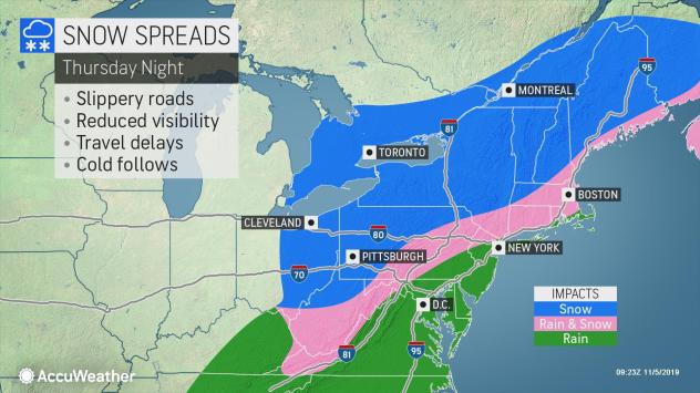
The cold and snow keep creeping farther south and east in the eastern United States, after weeks of being held up in Canada and the Rockies. While a fast-moving Alberta Clipper is expected to bring the first flakes of the season to parts of the interior Northeast during the middle of the week, a larger and more disruptive storm will eye much of the eastern U.S. to end the week.
“Residents throughout the Northeast, from Pittsburgh to Philadelphia to Binghamton, New York, and Bangor, Maine, will want to keep a close eye on this system for the potential for slippery, slushy roads and significant travel delays Thursday night and Friday,” Tom Kines, AccuWeather senior meteorologist, said.
This next storm will first douse the southern Plains as it takes shape late Wednesday. Rain will quickly slide eastward through the Ohio and Tennessee Valley Wednesday night and Thursday. As the rain continues to push into colder air enveloping areas farther north and east, it will change over to snow in portions of the western Ohio Valley, northern mid-Atlantic and New England.
“The precipitation will start as rain for most as it moves through the Ohio Valley into portions of the mid-Atlantic Thursday afternoon,” Brett Anderson, AccuWeather senior meteorologist, said. “On Thursday night, more areas on the northern and western side of the storm will see rain change over to snow as colder air is brought into the storm.”
While a major snowstorm is not anticipated, residents across much of northern and western Pennsylvania, southern New York and southern New England are likely to wake up with a fresh blanket of snow Friday morning. During the day Friday, snow will pivot northward through portions of New England as the storm takes a turn northward toward Atlantic Canada. It will also turn increasingly windy along the eastern New England coast as the storm will begin to intensify more rapidly.
In areas that receive all snow, amounts are generally expected to remain between 3-6 inches with a few locally higher totals. Interior New England, around the Berkshires and southern Green and White mountains, could have the best chance for higher snow totals, perhaps in the 6- to- 12-inch range.
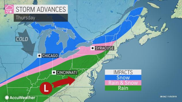
The Friday morning commute could be very slick in places like Pittsburgh, Binghamton and Albany, New York, and Springfield, Massachusetts.
However, some finer details of the storm still need to be worked out. A 50-mile difference in the storm track could mean the difference between locations receiving all rain or seeing some snow mix in. The I-95 corridor, including Philadelphia and New York City, may lie in this mixing zone.
“Just how close to the Atlantic coast rain will change over to snow remains a major question,” said Bill Deger, AccuWeather meteorologist. “If the storm tracks just a little farther south, New York City could mix with or even change over to all snow for a period during the storm.”
Farther to the north, where colder air will be more firmly entrenched at the onset of the storm, in cities like Boston and Providence, Rhode Island, the storm may start by dropping snow before the precipitation turns over to rain. Then, it could change back to snow again Thursday night and Friday, depending on how close the storm tracks to the southern New England coast and how quickly it turns north.
As snow and cold air sweep across the northern tier, and the heaviest rain is expected to fall farther to the west, from the southern Plains into the lower Ohio Valley, downpours and thunderstorms will still sweep from the lower Mississippi Valley through the Southeast on Thursday and Friday. A significant flooding or severe thunderstorm threat is not anticipated in the Southeast. Instead, the storms will mark the advance of some of the coldest air of the season throughout the region.

