[UPDATED June 20] – There are still ski areas open, but that doesn’t mean we can’t start looking to next winter. Yesterday, NOAA updated its long-lead seasonal outlooks, which include the winter 2025-26 season. We thought we’d take a quick look to see what might be in store for the U.S. next year.
Last season, our team of meteorologists graded NOAA a B+ for its long-lead outlook, accurately predicting almost everywhere except California. Will this season be as accurate?
Updated NOAA Winter 2025-26 Outlook (Based on June 2025 Discussion)
Climate Drivers
ENSO-neutral conditions are currently present and are favored to persist into early winter 2025-26, though confidence has decreased, with a 48% chance of Neutral and a 41% chance of La Niña for November–January. This means neither El Niño nor La Niña is likely to dominate, so decadal climate trends and local factors (such as soil moisture and sea surface temperatures) remain the primary influences on this winter’s outlook.
Temperature Outlook
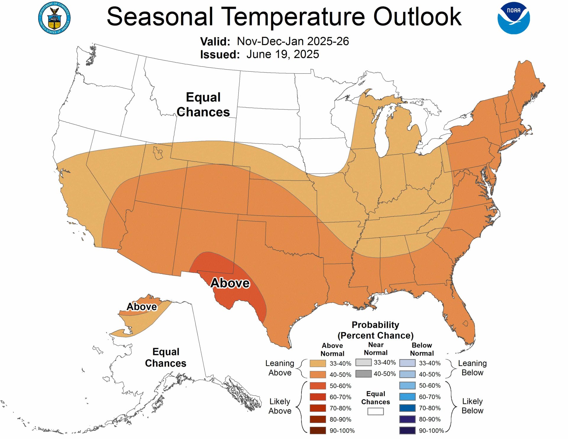
Early Winter (Nov 2025 – Jan 2026)
- Above-normal temperatures are expected across most of the United States, especially in the southern Rockies, Southwest, southern Plains, and much of the East and Midwest.
- The West Coast, Sierra Nevada, and central/northern Rockies are in the “Equal Chances” (EC) category, meaning no strong signal for above or below normal temperatures.
- Alaska is likely to experience warmer-than-normal temperatures, particularly along the southern and eastern coasts, while northwestern Alaska has an equal chance of experiencing below, near, or above-normal temperatures.
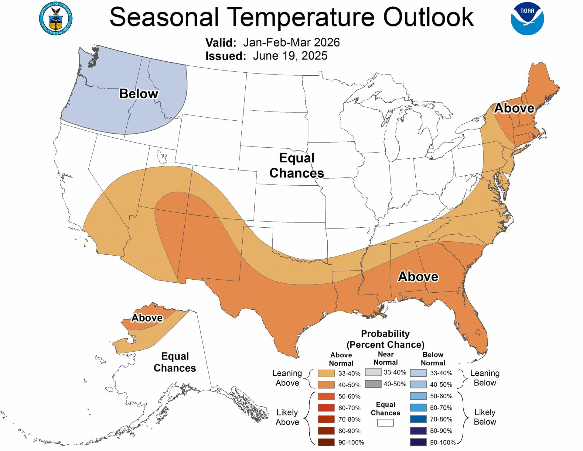
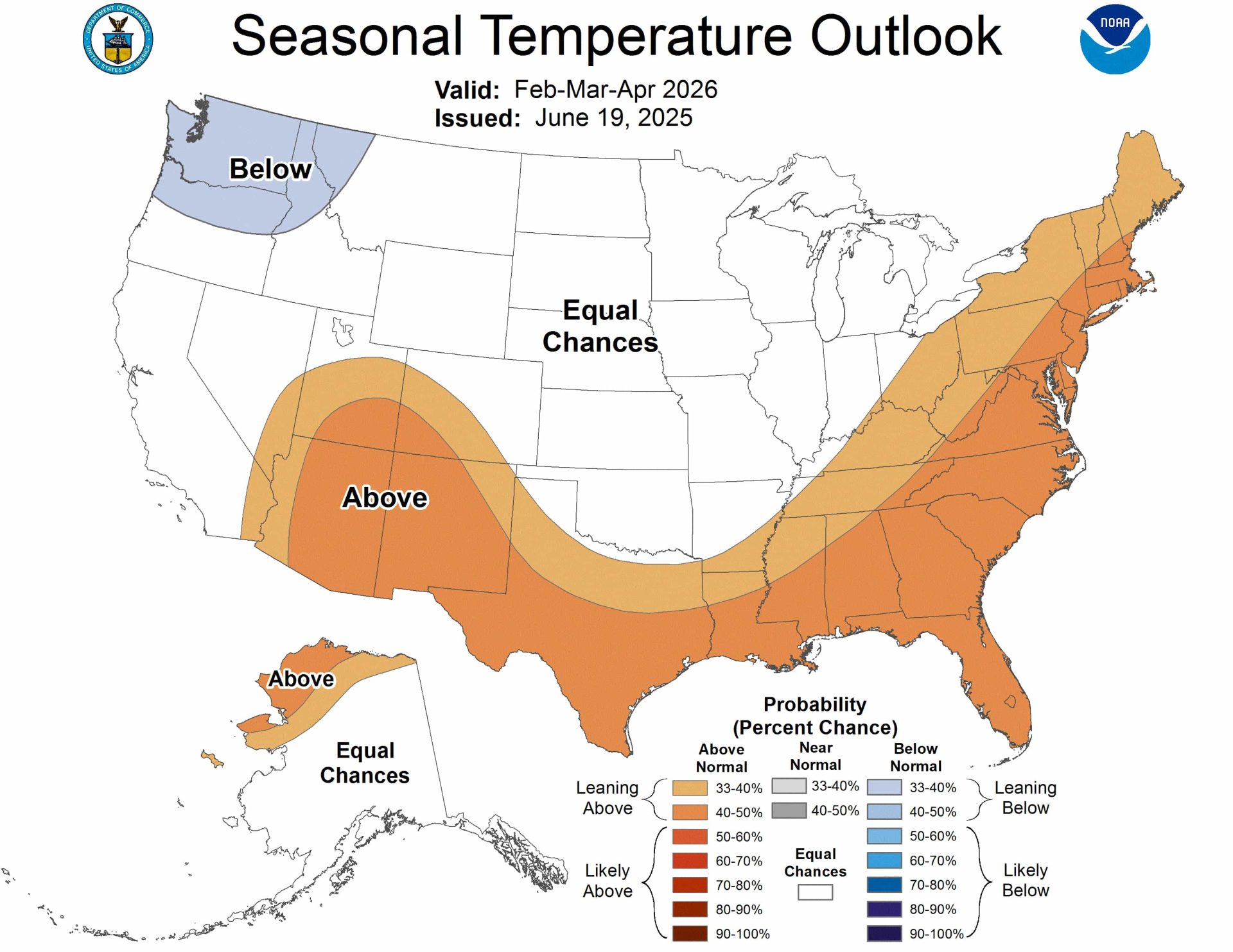
Late Winter (Feb – Apr 2026)
- Above-normal temperatures are likely to persist for the southern Rockies, Southwest, and much of the East.
- The Pacific Northwest—including Washington, northern Idaho, and northwest Montana—has elevated probabilities for below-normal temperatures, a notable shift from earlier outlooks and potentially favoring better snow conditions in the region.
- The central and northern Rockies, Sierra Nevada, and most of California remain in the “Equal Chances” category for temperature, so local weather will be important.
Precipitation Outlook
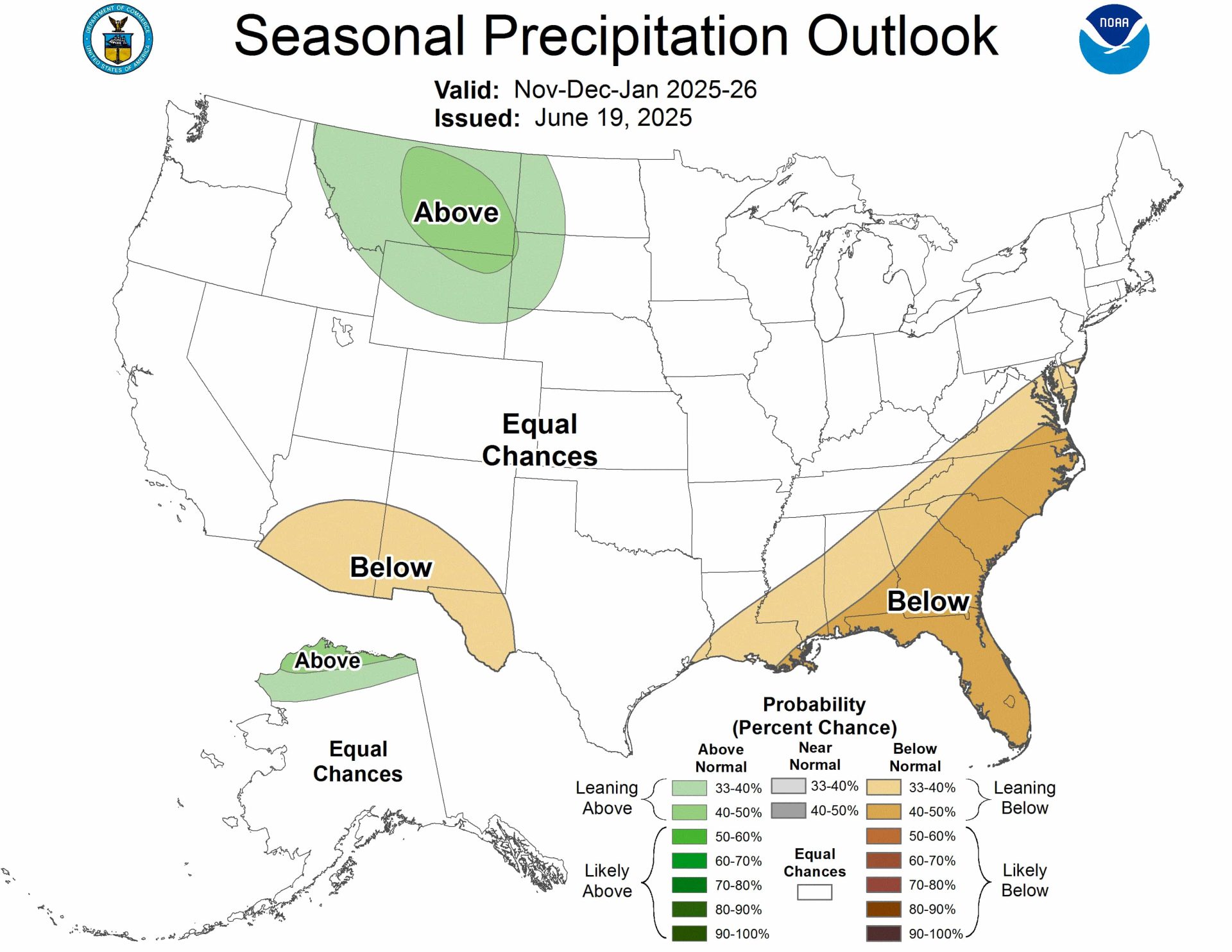
Early Winter (Nov 2025 – Jan 2026)
- Below-normal precipitation is now favored for the Pacific Northwest, northern Rockies, and north to central Great Plains, a change from last month’s outlook, which had favored above-normal precipitation for the Northwest.
- The Southwest—including southern Colorado, Utah, Arizona, and New Mexico—remains in the “Equal Chances” zone for precipitation, as model support for a dry or wet signal has weakened.
- The Sierra Nevada, central Rockies, and most of the West are also in the “Equal Chances” category.
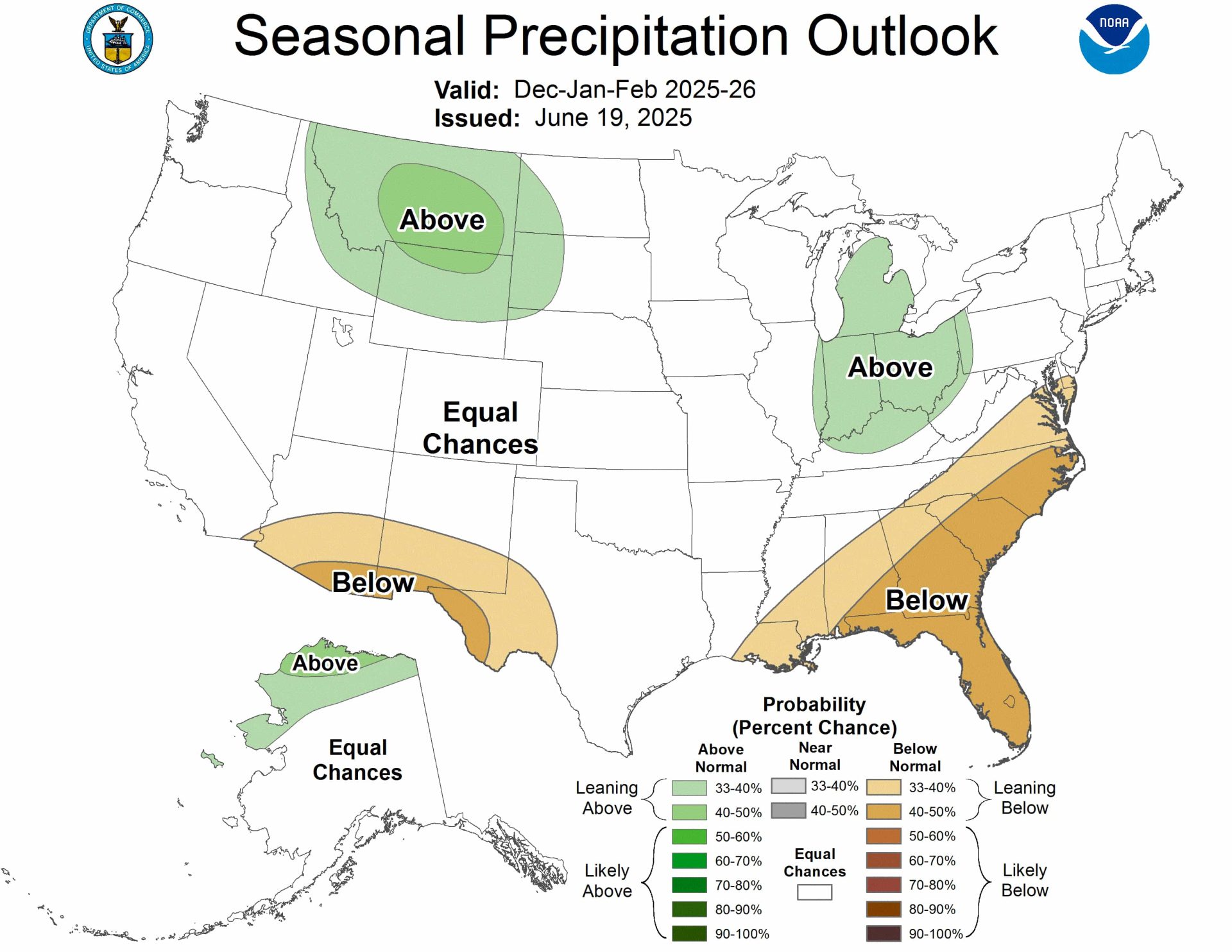
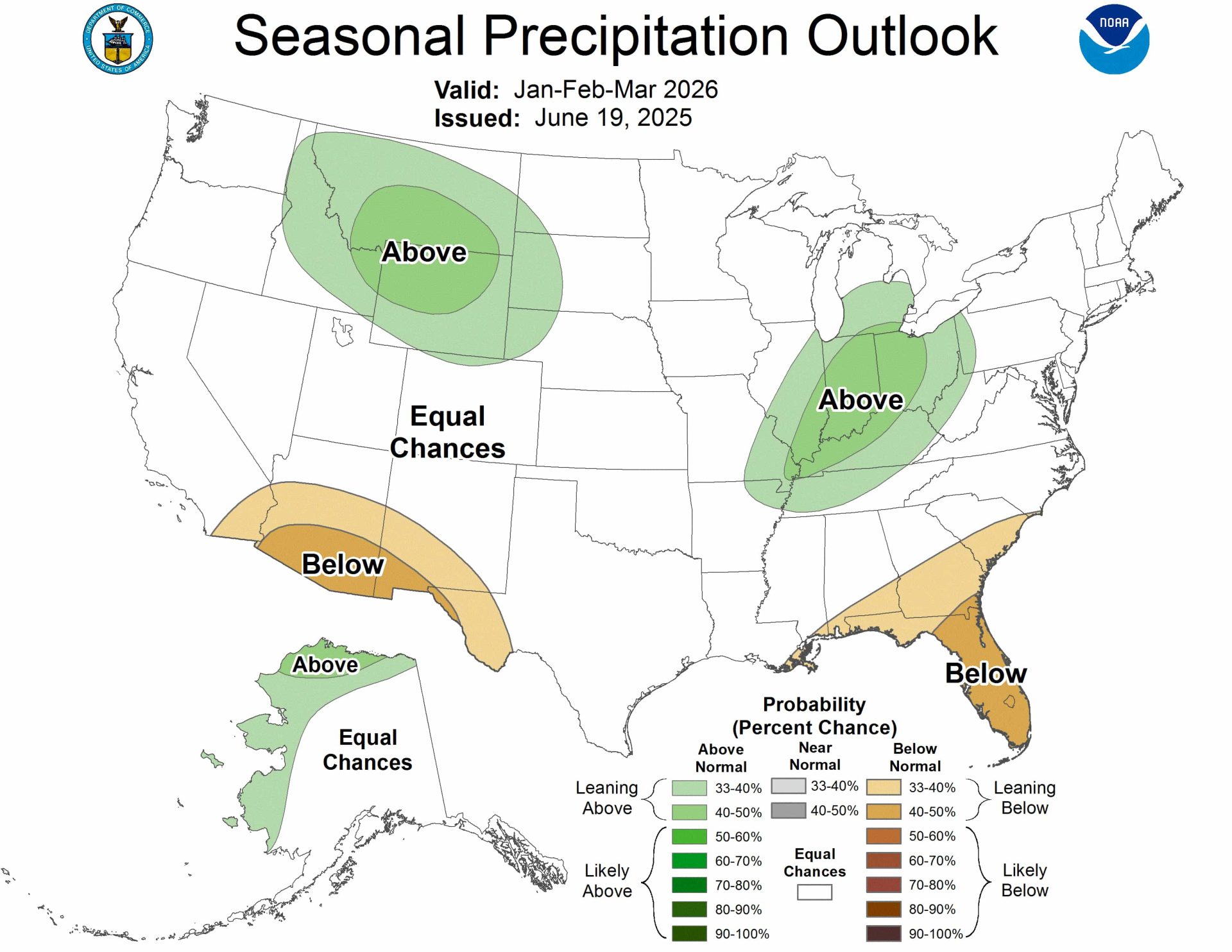
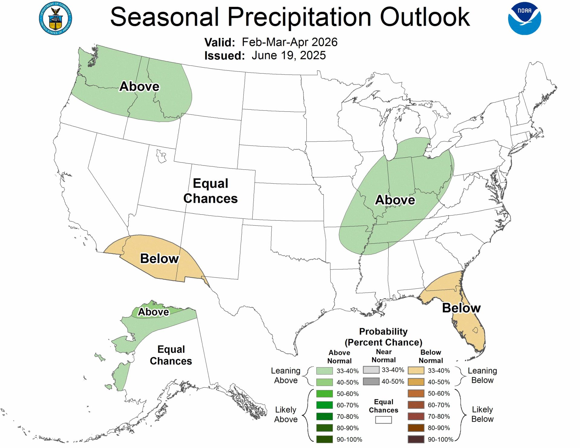
Late Winter (Feb – Apr 2026)
- Below-normal precipitation probabilities continue for the Pacific Northwest and northern Rockies, extending into the north and north-central Great Plains.
- The Southwest, including southern Colorado, Utah, Arizona, and New Mexico, remains in the “Equal Chances” category, meaning precipitation could go either way.
- The central and northern Rockies, Sierra Nevada, and most of California also remain in the “Equal Chances” zone for precipitation.
What This Means for Skiers and Snowboarders
Best Odds for Consistent Snow: The northern Rockies and Pacific Northwest, which previously stood out for above-normal precipitation, now face a tilt toward below-normal precipitation and cooler temperatures in late winter. This could favor better snow preservation, but may result in less overall snowfall, especially early in the season.
Challenging Areas: The Southwest (southern Colorado, Utah, Arizona, and New Mexico) is no longer strongly forecast to be drier than average, but the lack of a clear signal means snow reliability is uncertain and will depend on short-term weather patterns.
Uncertain Zones: The central Rockies (including Colorado’s major resorts) and the Sierra Nevada are in the “Equal Chances” zone for both temperature and precipitation, so local and short-term weather will be especially important for planning.
Bottom Line
- The Pacific Northwest and northern Rockies, which previously had the best prospects for above-normal snow, now face a drier outlook. However, late winter could bring cooler-than-normal temperatures that help preserve snowpack.
- The Southwest is no longer strongly forecast to be drier than average, but uncertainty remains high.
- The central Rockies and Sierra Nevada remain in a holding pattern, with no strong signal indicating whether winter will be wet or dry, warm or cold. Local forecasts will be key as winter approaches.
In summary: The latest NOAA update for winter 2025-26 shows a shift toward drier and cooler conditions in the Pacific Northwest and northern Rockies, less certainty for the Southwest, and continued “Equal Chances” for much of the West. Powder chasers should monitor local forecasts closely as the season nears.
Outlook Maps

Full NOAA Text Discussion
El Niño Southern Oscillation (ENSO)-neutral conditions continue with sea
surface temperatures (SSTs) near average over most of the equatorial Pacific
Ocean. ENSO-neutral is likely to persist through September (near 70% chance).
By the late fall and early winter (November-December-January, NDJ 2025-26),
ENSO-neutral is favored but confidence is lower with a 48% chance of
ENSO-Neutral and a 41% chance of La Niña.

The July-August-September (JAS) Temperature Outlook favors above-normal
temperatures throughout the lower 48 states with the highest forecast
confidence across the Great Basin and New England. The JAS outlook only
slightly leans towards above-normal temperatures for much of the Great Plains
and Mississippi Valley. Above-normal temperatures are also favored for eastern
and southern Alaska.

The JAS Precipitation Outlook depicts elevated above-normal precipitation
probabilities for the Mid-Atlantic, Southeast, and Upper Ohio Valley.
Below-normal precipitation is more likely across the Northern to Central Great
Plains, Northern Rockies, and Pacific Northwest. Above-normal precipitation is
favored for central and western Alaska.

Areas depicted in white and labeled “Equal-Chances” or “EC” are regions where
climate signals  are weak, and so there are equal chances for either above-,
near- or below-normal seasonal mean temperatures or total precipitation amounts.

BASIS AND SUMMARY OF THE CURRENT LONG-LEAD OUTLOOKS
Note: For Graphical Displays of the Forecast Tools Discussed Below See:
http://www.cpc.ncep.noaa.gov/products/predictions/90day/tools/briefing

CURRENT ATMOSPHERIC AND OCEANIC CONDITIONS

Weekly observed SSTs in the Niño 3.4 region are average with small positive SST
anomalies closer to the South American coast. Since late April, subsurface
temperature anomalies (averaged from 180-100W and 0-300 meters) are slightly
above-average. From May 20, 2025 to June 14, 2025, negative outgoing longwave
radiation (OLR) anomalies (enhanced convection and precipitation) continued
over Indonesia and northern Australia.  Near average OLR anomalies were present
throughout the rest of the equatorial Pacific. Both the low-level (850-hPa) and
upper-level (200-hPa) wind anomalies were near average across the central
equatorial Pacific. These atmospheric and oceanic conditions reflect
ENSO-neutral conditions.

The Madden-Julian Oscillation (MJO) has generally remained weak and incoherent
during the late spring as other modes of tropical variability (fast-moving
Kelvin waves and equatorial Rossby waves) dominate. The GEFS and ECMWF models
favor a continued weak MJO heading into July with fast-moving Kelvin waves the
primary influence on anomalous tropical rainfall and tropical cyclone
development.

PROGNOSTIC DISCUSSION OF SST FORECASTS

The CPC SST consolidation forecast for Niño 3.4 depicts ENSO-neutral conditions
persisting through August-September-October (ASO) as SST anomalies remain
between 0 and -0.5 degrees C. Later in the fall and heading into the early
winter, dynamical models  and statistical tools diverge on the ENSO state. In
addition, ensemble spread among the NMME members becomes large at the same
time. Most of the International Multimodel Ensemble (C3S) members favor
ENSO-neutral conditions persisting through the fall. The CPC ENSO outlook
indicates that ENSO-neutral is likely during JAS (near 70 percent chance) but
those probabilities decline closer to 50 percent by the fall season. During the
2025-2026 winter (DJF), either ENSO-neutral or La Niña is the most likely
outcome.

PROGNOSTIC TOOLS USED FOR U.S. TEMPERATURE AND PRECIPITATION OUTLOOKS

The Temperature and Precipitation Outlooks for JAS 2025 were based on dynamical
models such as the North American Multi-Model Ensemble (NMME) and the
Copernicus (C3S) multi-model ensemble system. A Calibration, Bridging, and
Merging (CBaM) version of the NMME was also used in the outlooks. An objective,
historical skill-weighted consolidation that includes the NMME along with
statistical tools such as the SST-based Constructed Analog and the ENSO-OCN was
used through November-December-January (NDJ) 2025-2026. Beyond that time, the
consolidation only includes statistical tools. Long-term climate trends  were
considered for all leads, but were relied upon most during the 2026 spring and
summer.

PROGNOSTIC DISCUSSION OF OUTLOOKS - JAS 2025 TO JAS 2026

TEMPERATURE

The highest forecast confidence for above-normal temperatures (probabilities
more than 60 percent) during JAS 2025 is across the Great Basin and New England
where there is excellent agreement and consistency among the dynamical models .
Although above-normal temperatures are favored throughout the lower 48 states,
probabilities are limited (less than a 40 percent chance) across most of the
central contiguous U.S. (CONUS). The smaller above-normal temperature
probabilities for the Lower Mississippi Valley and Tennessee Valley are
consistent with high soil moisture and favored wetness during this three-month
period. Above-normal temperatures are most likely across eastern and southern
Alaska, while the NMME and nearby negative SST anomalies result in equal
chances of below, near, or above-normal temperatures for northwestern Alaska.

Compared to the previous month, the NMME depicts lower above-normal temperature
probabilities for the northwestern and north-central CONUS from the late summer
through the fall. Beginning in August-September-October, EC of below, near, or
above-normal temperatures are forecast for parts of the north-central CONUS and
the coverage of EC expands in spatial coverage through the fall. Since
ENSO-neutral or La Niña is favored during the late fall and 2025-2026 winter,
the temperature outlook generally followed those temperature composites along
with the consolidation. Elevated below-normal temperature probabilities are
forecast for the northwestern CONUS beginning in December-January-February
2025-2026 through February-March-April 2026. Following this, long-term trends
became the major factor in the temperature outlook during the 2026 spring and
summer.

PRECIPITATION

During JAS 2025, below-normal precipitation remains the most likely outcome for
the Pacific Northwest, Northern Rockies, Northern to Central Great Plains, and
parts of the Upper Mississippi Valley. The NMME has maintained this dry signal
dating back to February. In addition to the good model consistency, the C3S,
CBaM, and consolidation support an increased chance of below-normal
precipitation for those areas. One notable change in the NMME from one month
ago is the lack of a dry signal across the Southern Great Plains. The JAS
outlook now calls for EC of below, near, or above-normal precipitation from
southern Kansas southward through Oklahoma and much of Texas. Although
above-normal precipitation was favored across the Southwest during JAS in
previous outlooks, EC of below, near, or above-normal precipitation are now
forecast for this region since the July outlook has EC and there is no
dynamical model support for leaning towards the wet side. Based on the NMME,
C3S, and consolidation, above-normal precipitation is most likely across the
Mid-Atlantic and Southeast. Compared to the JAS outlook released in May, the
elevated above-normal precipitation probabilities were expanded west to include
the Upper Ohio Valley and Tennessee Valley due to changes in the dynamical
model output. The NMME and C3S support an increased chance of above-normal
precipitation across the western two-thirds of Alaska for JAS.

Similar to JAS, the dry signal among the dynamical models  diminished in
coverage throughout the central CONUS for August-September-October (ASO) and
only a slight lean towards below-normal precipitation (33 to 40 percent chance)
is forecast across the Northern to Central Great Plains and Upper Mississippi
Valley. A slight lean towards above-normal precipitation was maintained for
parts of the Mid-Atlantic and Southeast during ASO and
September-October-November (SON) which is consistent with an increased chance
of an above-normal Atlantic hurricane season. Also, there is a wet signal in
the NMME and C3S during ASO. Since the SST-based Constructed Analog loses the
wet signal across the Southwest during ASO and there is no dynamical model
support for favoring above-normal precipitation, EC of below, near, or
above-normal precipitation are forecast for the Southwest. During
November-December-January (NDJ) and December-January-February (DJF) 2025-2026,
below-normal precipitation probabilities were slightly increased across the
Southeast since the chances for El Niño developing by next winter are only at
near 10 percent. EC is forecast for a majority of the forecast domain during
the 2026 spring and summer except for an increased chance of below-normal
precipitation for parts of the northwestern and north-central CONUS.