Last week, the NOAA released its monthly outlook for June 2025. Below is a summary for those unfamiliar with meteorological terminology, and the full discussion further down for those who are.
TL;DR: June 2025 is forecast to be hotter than normal across most of the U.S., especially the Southwest, with the greatest odds for below-normal precipitation from the northern Rockies into the central High Plains, while the East is likely to be warmer and wetter than average
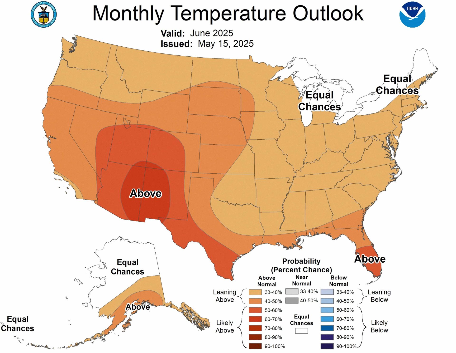
Temperature Outlook
Southwest Region
- Highest confidence for above-normal temperatures with probabilities exceeding 60%
- Most intense warming centered over Arizona and New Mexico
- Driven by low soil moisture conditions and consistent with decadal warming trends
Western States
- Generally above-normal temperatures expected
- Probability decreases moving northward through the region
- Southern areas show stronger warming signal than northern areas
Central and Southern Plains
- Above-normal temperatures likely but with lower confidence
- Oklahoma and northeastern Texas show reduced warming probability due to high soil moisture (above 90th percentile)
Eastern United States
- Increased chance of above-normal temperatures across most areas
- Florida Peninsula shows strongest signal with probabilities exceeding 50%
- Supported by both model forecasts and observed warming trends
Northeast and Great Lakes
- Equal chances (EC) of below, near, or above-normal temperatures
- Limited forecast signal in models and more neutral temperature trends
Alaska
- Above-normal temperatures likely across southern portions
- Equal chances forecast for northern two-thirds of mainland Alaska
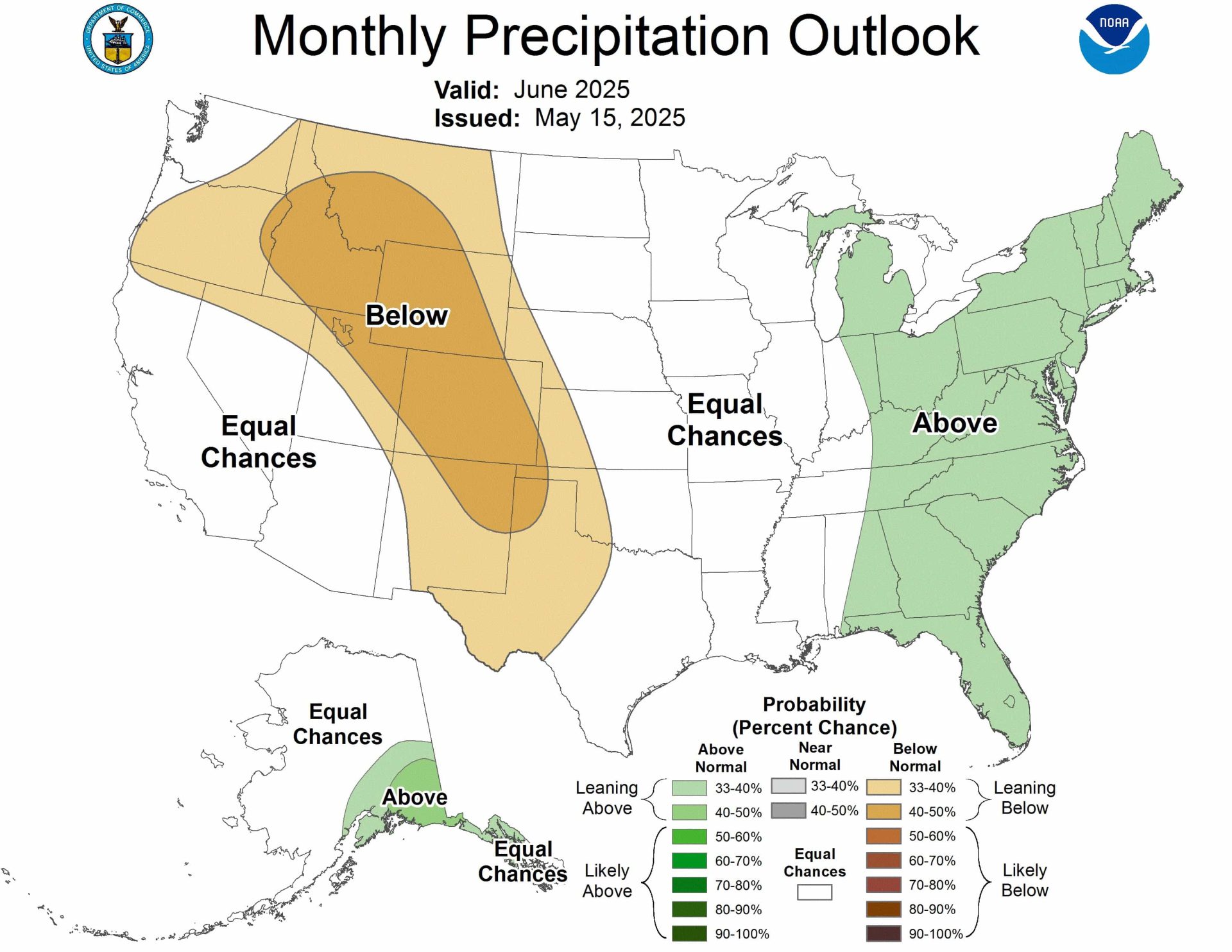
Precipitation Outlook
Western Interior
- Below-normal precipitation favored for Pacific Northwest, northern Intermountain West, Great Basin, Rockies, and High Plains
- Strongest dry signal (probabilities >40%) extends from Idaho/southwestern Montana to the southern High Plains
- High confidence based on agreement between forecasting tools
California and Southwest
- Equal chances forecast for climatologically drier areas
- Potential early, robust start to the Monsoon suggested by some indicators
- May 31st update will reevaluate this region as models show mixed signals
Central United States
- Equal chances across much of the Great Plains and Mississippi Valley
- High uncertainty in predicting convective rainfall patterns
Eastern United States
- Slight lean towards above-normal precipitation
- Light green coloring on outlook map indicates moderate confidence
- Weak but consistent signal from multiple forecasting tools
Alaska
- Above-normal precipitation most likely across southeastern parts
- Supported by forecasting models and trends
The outlook reflects complex interactions between soil moisture conditions, climate trends, and seasonal patterns, with highest confidence in Southwest warming and Western interior drying for June 2025.
30-DAY OUTLOOK DISCUSSION FOR JUNE 2025

The June 2025 Temperature and Precipitation Outlooks are based on the: North
American Multi-Model Ensemble (NMME) and International Multi-Model Ensemble
(IMME), consolidation (statistical and dynamical tools), soil moisture
influence and its constructed analog, and decadal trends . The Madden-Julian
Oscillation (MJO) remains weak and dynamical model spread is high on whether
the MJO may strengthen heading into June. Although the MJO is unlikely to
affect the mid-latitude circulation pattern during June, it will be closely
monitored as it could contribute to a more favorable environment for an early
season tropical cyclone in the Atlantic basin. ENSO-neutral conditions are
forecast to continue throughout June.

The highest forecast confidence in the temperature outlook is for above-normal
temperatures (probabilities greater than 60 percent) across the Southwest,
based on the calibrated NMME, warming influence from low soil moisture, and
consistent with decadal trends . The June outlook reflects the NMME and IMME
with their decreasing above-normal temperature probabilities farther to the
north over the West. Probabilities are also lower across much of Oklahoma and
northeastern Texas where high soil moisture (above the 90th percentile) would
have a cooling effect on surface temperatures in the coming weeks. In addition,
a constructed analog derived from soil moisture depicts a weak cold signal. The
NMME and the decadal trend support an increased chance of above-normal
temperatures for most of the East with the largest probabilities (exceeding 50
percent) forecast across the Florida Peninsula. Due to little or no signal in
the NMME and a more neutral trend, equal chances (EC) of below, near, or
above-normal temperatures are forecast for parts of the Northeast and Great
Lakes. Consistent with the NMME and decadal trends , above-normal temperatures
are more likely across the southern tier of Alaska with EC forecast for the
northern two-thirds of Mainland Alaska.

Based on the NMME, IMME, constructed analog from soil moisture, and trend,
below-normal precipitation is favored for parts of the Pacific Northwest,
northern Intermountain West, Great Basin, Rockies, and High Plains. The largest
below-normal precipitation probabilities (greater than 40 percent) extend from
Idaho and southwestern Montana southeastward to the southern High Plains where
the dynamical model output and statistical tools are in the best agreement. In
the climatologically drier areas of California and the Southwest, EC is
forecast. The constructed analog using sea surface temperatures depicts a wet
signal for the Southwest, implying an early, robust start to the Monsoon. This
would also be consistent with ongoing low soil moisture for the Southwest.
However, forecast confidence was not high enough at this time to lean towards
above-normal precipitation, given the lack of dynamical model support, but this
region will be reevaluated for the update released on May 31st. A broad area
with EC covers much of the Great Plains and Mississippi Valley due to a weak
signal among the precipitation tools along with large uncertainty in predicting
areas of anomalous convective rainfall at a half-month lead. A slight lean
towards above-normal precipitation is forecast for the East and parts of the
Great Lakes with the NMME, IMME, constructed analog from soil moisture, and
trend at least having a weak signal for a wetter-than-normal June. For Alaska,
above-normal precipitation is most likely across southeastern parts of the
state which is supported by the NMME and trend.