Yesterday, the NOAA released its monthly outlook for July 2025. Below is a summary for those unfamiliar with meteorological terminology, and the full discussion further down for those who are.
tl;dr: In July 2025, the western U.S. is expected to be hotter and drier than usual, especially in the northern Rockies and northern Plains, while the eastern U.S. is likely to experience warmer and wetter conditions. Central and parts of the Southwest U.S. have equal chances for above, below, or near-normal temperature and precipitation.
Temperature Outlook
West, Rockies, and Northern U.S.
- Western U.S., Rockies, Northern Plains, Upper Midwest, Great Lakes, and Northeast: Expect a hotter-than-normal July. The strongest signal for above-average temperatures is in the West and the Rockies, where both computer models and recent dry conditions point to a warm month.
- Northern tier (Plains to Northeast): Warmer than usual, but the confidence is a bit lower than in the West.
South and Southeast
- Gulf Coast, Florida, and Southeast: These areas are also likely to be warmer than usual, influenced by warm ocean waters nearby.
Alaska
- Southeast Alaska: Warmer-than-normal temperatures are likely.
- Southwest Mainland Alaska: Cooler than normal temperatures are expected, especially early in the month, due to cool ocean temperatures nearby.
Central U.S. (Mid-South, Tennessee Valley, Lower Ohio Valley, Carolinas)
- Central U.S. and parts of the East: There’s no strong signal for above or below normal temperatures, so any outcome is possible (“equal chances”). This is partly because recent heavy rains have left the ground wetter than usual, which can help keep temperatures closer to normal.
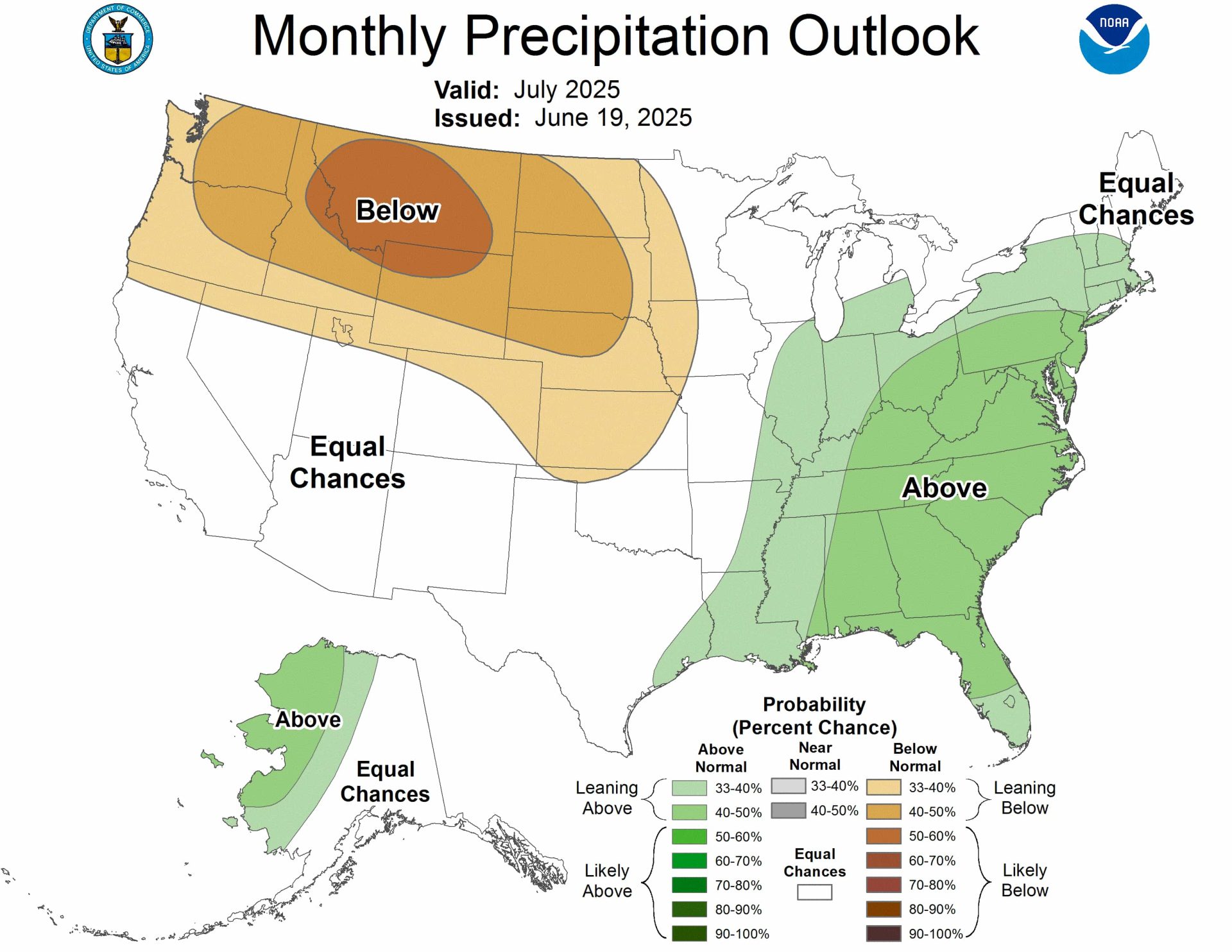
Precipitation Outlook
West and Northern Plains
- Pacific Northwest, Northern Rockies, Northern and Central Plains: Expect drier than normal conditions. The highest chance for less rain is in parts of Montana, Idaho, and Wyoming, where the odds are strongest for a dry July.
Southeast, Ohio Valley, Mid-Atlantic, and Northeast
- Southeast, Ohio Valley, Mid-Atlantic, Northeast: These regions are likely to see more rain than usual. While the increase isn’t dramatic, there’s a clear trend toward wetter conditions for July.
Alaska
- Western Mainland Alaska: Rainfall is expected to be higher than usual, especially in the western part of the state.
- Other parts of Alaska: No strong signal for more or less rain—any outcome is about equally likely.
Southwest and Central U.S.
- Southwest (including the monsoon region) and much of the central U.S.: There’s no firm indication of wetter or drier conditions, so any outcome is possible (“equal chances”).
Summary
In July 2025, the western and northern parts of the United States, including the Pacific Northwest, northern Rockies, and northern Plains, are expected to be both hotter and drier than usual, with the strongest chances for above-normal temperatures and below-normal rainfall centered over Montana, Idaho, and Wyoming. The central part of the country, including the Southwest and much of the Midwest, has no clear trend for either temperature or precipitation, meaning conditions could go either way. In contrast, the eastern U.S.—from the Southeast through the Ohio Valley and up into the Northeast—is likely to see both warmer and wetter conditions than average. Along the Gulf Coast and in Florida, above-normal temperatures are also favored. In Alaska, western areas are expected to be wetter than usual, while the southeast will likely be warmer, and the southwest could be cooler than normal.
What This Means for You
- West and Northern Plains: Prepare for a hot and dry July—water conservation may be necessary.
- East and Southeast: Expect warmer and wetter conditions, which could mean more thunderstorms and humid weather.
- Central U.S.: No strong trends—weather could go either way.
- Alaska: Western Alaska will be wetter, while the southwest will be cooler and the southeast will be warmer than usual.
These predictions are based on a combination of computer models, recent weather patterns, and current ground and ocean conditions. The outlook uses averages from 1991 to 2020 as a reference point.
The full discussion is below:
Prognostic Discussion for Monthly Outlook
NWS Climate Prediction Center College Park MD
830 AM EDT Thu Jun 19 2025


30-DAY OUTLOOK DISCUSSION FOR JULY 2025

The July 2025 temperature and precipitation outlooks are primarily based on a
combination of dynamical model guidance [both Week 3-4 and integrated monthly
(North American Multi-Model Ensemble (NMME), Copernicus multi-model ensemble
system (C3S))], statistical forecast guidance, and current surface conditions.
Although there has been considerable coherent subseasonal tropical variability
in the form of atmospheric Kelvin wave activity, the Madden-Julian Oscillation
(MJO) has weakened substantially from its state in late May and early June.
Moreover, forecasts of the MJO over the next few weeks do not predict any
clear, reliable strengthening of the signal and so the MJO does not play a role
in preparation of the July outlooks. Current land surface states such as
anomalous soil moisture did contribute considerably to the outlooks for the
upcoming month.

The temperature outlook favors above-normal monthly mean temperatures for the
western half of the contiguous U.S. as well as eastward across the northern
Plains, upper Mississippi Valley, Great Lakes, and Northeast. Above-normal
temperatures are also favored along the Gulf coast, including all of Florida,
and for Southeast Alaska. Probabilities are greatest for the western U.S. where
warmer than normal conditions are overwhelmingly favored by both dynamical and
statistical model guidance, long-term positive temperature trends , and drier
than normal surface conditions in many areas. The odds for above-normal
temperatures across the northern tier of the U.S. from the Plains to the
Northeast are lower due to somewhat less agreement in model guidance and
varying surface conditions.

Warmer than normal sea surface temperatures (SSTs) and some forecast tools
favor a slight tilt toward above-normal temperatures for the Gulf coast and
Florida.

Ocean surface temperatures and potential weak ridging in dynamical model
guidance elevates odds slightly for warmer than normal temperatures in
proximity to Southeast Alaska. Alternatively, forecast troughing during the
first half of July and cooler than normal SSTs in the Bering Sea favors an area
of below-normal temperatures for a small region in Southwest Mainland Alaska.

A large area of quite wetter than normal surface conditions from frequent and
heavy precipitation events this late winter and spring were observed from the
south-central Plains eastward to the Atlantic seaboard. This is likely to
offset, to some degree, periods of warmer than normal conditions during July
and interject considerable uncertainty for the eventual July monthly mean
temperatures. So a forecast for "Equal-Chances" (EC) of either of the three
categories is forecast from the Plains eastward across the mid-South, Tennessee
Valley, lower Ohio Valley and Carolinas.

For precipitation, both dynamical and statistical model guidance, long-term
negative precipitation trends , in some areas, and drier than normal surface
conditions support elevated odds for below-normal July monthly total
precipitation amounts for the Pacific Northwest, northern Rockies and the
northern and central Plains. The most likely area for drier than normal
conditions is for parts of Montana, Idaho and Wyoming.

Forecast troughing during the first half of July centered in the Bering Sea
supports elevated odds for above-normal precipitation for much of western
Mainland Alaska. The majority of NMME and C3S monthly precipitation forecasts
are consistent with this wet signal.

Long-term positive precipitation trends  and NMME and C3S monthly dynamical
model guidance favor above-normal precipitation for the Southeast, Ohio Valley,
mid-Atlantic and much of the Northeast. Probabilities are modest overall for
this region.

Large variability from both dynamical and statistical model guidance and quite
unusual late Spring temperature and precipitation conditions, makes the
forecast for the Southwest monsoon region highly uncertain. Given this, the
most appropriate forecast in this area for July 2025 is EC as either of the
three categories are equally likely given the above information at this point
in mid-June.

FORECASTER: Jon Gottschalck

The climatic normals are based on conditions between 1991 and 2020, following
the World Meteorological Organization convention of using the most recent 3
complete decades as the climate reference period.  The probability anomalies
for temperature and precipitation based on these new normals better represent
shorter term climatic anomalies than the forecasts based on older normals.

An updated monthly outlook... for Jul will be issued on Mon June 30 2025

These outlooks are based on departures from the 1991-2020 base period.
$$