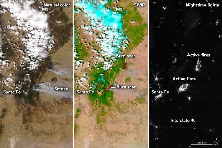
Fire season in New Mexico arrived early and aggressively in 2022, fueled by strong, gusty winds, extremely low humidity, and an exceedingly dry landscape. As of April 19, nearly 99 percent of the state was dealing with some level of drought, according to the U.S. Drought Monitor, with 63 percent rated at extreme to exceptional levels of dryness. Amid those conditions, nearly 137,000 acres of forests and grasslands were burning in five major fires across New Mexico on April 25.
The images above provide three satellite views of the area near Santa Fe on April 23. The natural-color and false-color (shortwave infrared and visible light, bands 7-2-1) images were acquired by the Moderate Resolution Imaging Spectroradiometer (MODIS) on NASA’s Aqua satellite. The false-color view makes it easier to distinguish the burn scar on the landscape. The nighttime view was acquired around 2 a.m. local time on April 23 with the Visible Infrared Imaging Radiometer Suite (VIIRS) on the NOAA-NASA Suomi NPP satellite.
To the east of Santa Fe, the Hermits Peak fire had consumed 56,478 acres and was 12 percent contained as of April 25. The event began as a prescribed burn in part of the Santa Fe National Forest, but erratic, gusty winds blew it out of control. Strong winds on April 22-23 pushed the fire through steep terrain and caused a merger with the Calf Canyon fire, creating a fire complex with more than 180 miles of perimeter. Residents in parts of San Miguel, Mora, and Colfax counties were told to evacuate their homes.
To the northeast, the Cooks Peak fire burned through 51,982 acres and was 9 percent contained by the morning of April 25.
Nearly 1,000 state and federal firefighters were working to contain the Cooks Peak and Hermits Peak blazes, as well as three others across northern New Mexico. According to news reports, hundreds of structures have been burned. Calmer winds and cooler weather on April 24 aided the fire crews, as did some light snow and rain on April 25. But dry and windy conditions are back in the forecast for later this week.
According to the National Interagency Fire Center on April 25, fourteen large, active fires were burning across 244,000 acres in eleven states. Since the start of 2022, at least 20,262 wildfires have burned 865,290 acres in the United States, well above the 10–year average through April.
In research published in November 2021, scientists found that burned acreage from wildfires in the western United States doubled between the period of 1984–2000 and 2001–2018. They attributed the increase in fire to a significant change in the vapor pressure deficit, a measurement of how hot and dry the atmosphere can get. Global warming, they noted, has been intensifying vapor pressure deficits, making vegetation more susceptible to burning and the atmosphere more conducive to sustaining fire. Other researchers also found that wildfires have been spreading to higher elevations in the U.S. West in recent decades.
This post first appeared on NASA Earth Observatory and was written by Michael Carlowicz. NASA Earth Observatory images by Joshua Stevens, using MODIS data from NASA EOSDIS LANCE and GIBS/Worldview, and the Suomi National Polar-orbiting Partnership.


