For remote sensing scientists who track the movement of smoke plumes, May 2023 has been a wild, memorable month due to extreme fire activity in northwestern Canada.
Early spring always brings elevated fire risk to Alberta, Saskatchewan, and the northeastern edge of British Columbia—naturally dry areas that lie in the rain shadow of the Canadian Rockies. There is a period each year after the snow melts, but before spring growth begins, that dry forest undergrowth is exposed.
But in May 2023, this naturally fire-prone dry period coincided with unusually hot and windy weather, turning what normally would have been small, short-lived fires into huge wildland blazes that raged for several weeks. The fires, ignited by lightning or human activity, charred more than 1 million hectares (400 square miles) as of May 24 and lofted smoke high into the atmosphere and across North America.
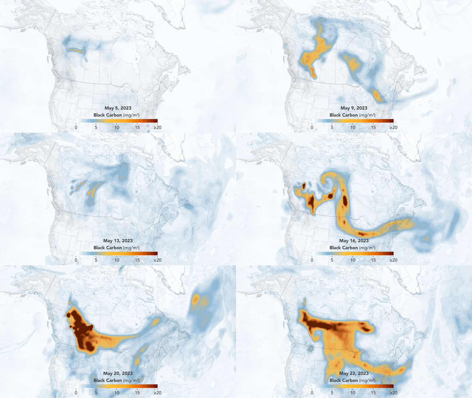
The animation above highlights the volume of smoke and its dynamic, swirling movements between May 5-22, 2023. It shows black carbon particles—commonly called soot—moving across North American skies during that period. The black carbon data come from NASA’s GEOS forward processing (GEOS-FP) model, which assimilates data from satellites, aircraft, and ground-based observing systems. In addition to using satellite observations of aerosols and fires, GEOS-FP also incorporates meteorological data like air temperature, moisture, and winds to project the plume’s behavior.
Over the course of the fire outbreak, large rivers of smoke traced meanders in the jet stream, swirled into two separate extratropical cyclones, and darkened skies across large swaths of North America for weeks. Scientists even used satellites to track smoke injected high into the atmosphere by Canadian wildfires as it circled the entire globe early in the month.
“None of this is unprecedented. We have seen smoke from this region behave like this in the past,” he said. “But the amount of smoke is unusual for this time of year.”
– Michael Fromm, a meteorologist at the U.S. Naval Research Laboratory who has observed the dynamics of smoke plumes with colleagues from NOAA, NASA, and several other science institutions for decades

On several occasions, the unusually hot and intense fires generated strong updrafts that fueled pyrocumulonimbus clouds (pyroCb)—also called flammagenitus. These towering clouds lift smoke from the surface and channel large volumes of it into the lower stratosphere where stronger, higher-level winds disperse it widely, explained David Peterson, also with the U.S. Naval Research Laboratory.
“Multiple pyroCbs in Alberta injected large amounts of smoke higher than the cruising altitudes of jet aircraft on May 4 and 5,” Peterson said. A second cluster occurred May 18-21, when pyroCbs were observed over fires in British Columbia and Alberta on four consecutive days. Around both periods, the area covered by smoke expands significantly in the GOES animation. “In total, we have observed at least 10 large pyroCb events in Canada in May,” he added.
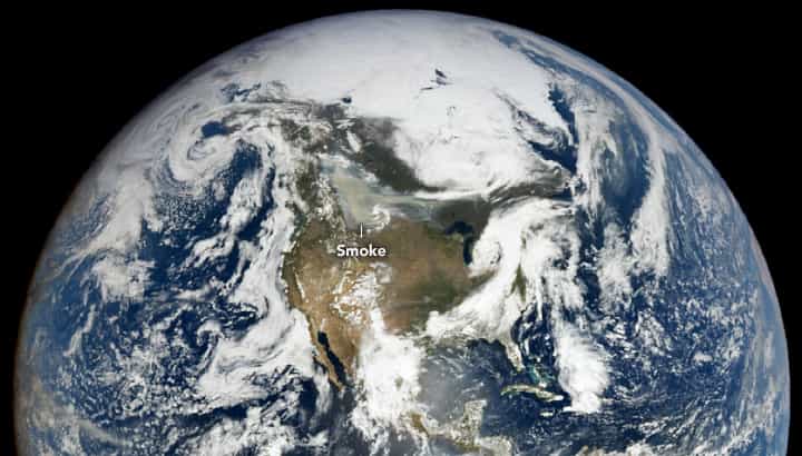
Also impressive to long-time smoke watchers has been how smoke became wrapped into the circulation of extratropical cyclones and lifted upward on two separate occasions—on May 16 and 19. NASA’s Earth Polychromatic Imaging Camera (EPIC) on NOAA’s DSCOVR satellite acquired the image above on May 20, 2023, when a river of smoke was still caught up in the circulation of the storm as it passed over Saskatchewan.
“This is rare to see with smoke plumes,” said Fromm, noting this is only the fourth time he can remember it happening in decades of observing smoke. It is much more common to see dust in parts of Asia and the Middle East, he added. In an earlier study, Fromm and colleagues documented how dust may alter the lifespan of certain types of storm clouds and change precipitation patterns. “There’s reason to think that infusions of smoke into extratropical storms could do something similar, but I’m unaware of any peer-reviewed publications that detail a case like that. I suspect this event in Canada will be an event we study and publish on for years,” he said.
Much of the smoke has stayed high enough to avoid creating severe air quality problems at the surface, but its presence has not gone unnoticed. Air quality alert systems managed by the National Weather Service and Environmental Protection Agency—as well as multiple state agencies—have issued alerts to several U.S. states. And skies have been hazier and sunsets redder than usual in many areas, according to news reports.
“This event is a good reminder of how interconnected we are,” said Jessica McCarty, chief of the branch of the biospheric science at NASA’s Ames Research Center and the author of a 2021 study about boreal and Arctic fire emissions. “What happens with wildland fires at high latitudes in boreal forests doesn’t just stay there,” she said. “The air quality and climate impacts affect all of us living in the temperate zone as well.”
This post first appeared on NASA Earth Observatory. NASA Earth Observatory images by Lauren Dauphin, using GEOS-5 data from the Global Modeling and Assimilation Office at NASA GSFC and data from DSCOVR EPIC. Story by Adam Voiland, with information from Colin Seftor (SSAI), David Peterson (USNRL), Jessica McCarty (NASA Ames), and Michael Fromm (USNRL).


