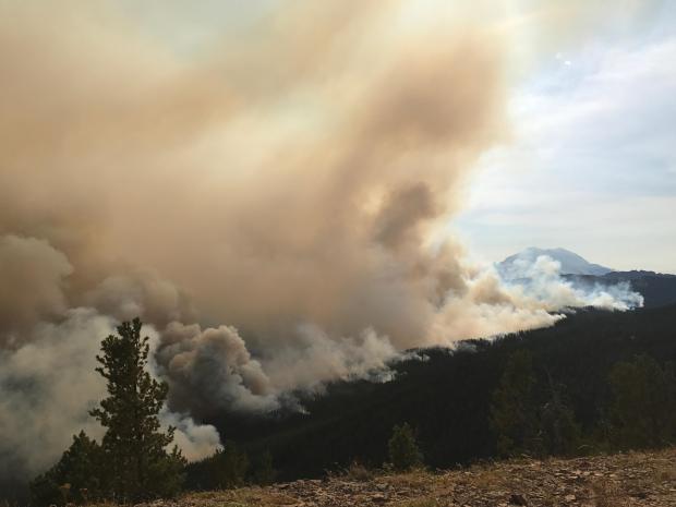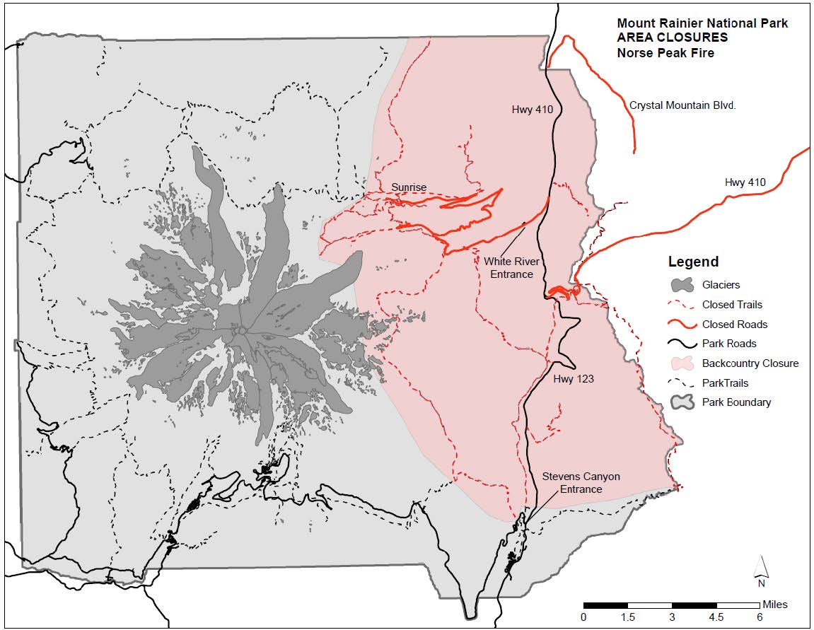
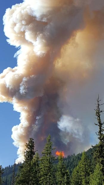
The unpredictability of the Norse Creek Fire has forced Mt. Rainier National Park, WA to close its White River & Sunrise areas of the park. All together, about 33% of the park is now closed. The Norse Peak Fire has not yet entered the park.
“Effective immediately, Mount Rainier National Park has closed the northeast portion of the park due to the unpredictable fire behavior of the Norse Peak Fire.” – Mt. Rainier National Park, today
This is the same fire that is burning within the boundaries of Crystal Mountain Ski Resort, WA.
Many trails, roads, campgrounds, and Crystal Mountain ski resort itself are currently closed due to the Norse Peak Fire (full details below).
Many regions in the Mt. Rainier area have been evacuated (full details below).
Mount Rainier Closes White River and Sunrise Areas of the Park
by Mount Rainier National Park
|
Date: September 5, 2017 Contact: Kathy Steichen, 360-569-6510
Effective immediately, Mount Rainier National Park has closed the northeast portion of the park due to the unpredictable fire behavior of the Norse Peak Fire. This fire is burning outside the east boundary of the park. Currently the Sunrise Road is closed between the junction with SR 410 near White River and Sunrise. The portions of SR 410 to Cayuse Pass and SR 123 within the park are open.
Backcountry closures include all of the trails and cross country zones on the east side of the park including the area from Frozen Lake to Panhandle Gap, and all of the trails with trailheads along SR 410 and SR 123 north of Stevens Canyon Entrance. Hikers in the closed area will be contacted when possible. Folks who are planning on picking up hikers at trailheads within the closed area should contact the park at 360-569-6510.The park has issued a Level 2 advisory for the White River Campground. Campers have been encouraged to leave the campground and advised that they should be packed and ready to go in the event of a mandatory evacuation.
Level 2 means BE READY. This level indicates there is significant danger in the area and people who choose to remain should be prepared to leave at a moment’s notice. Other road closures due to the Norse Peak fire include SR 410 east between Cayuse Pass and the Bumping River Road and Crystal Mountain Boulevard. A detour for SR 410 traffic is available via SR 123 and US 12 over White Pass. Updates on the fire can be found at https://inciweb.nwcg.gov/incident/5509/. |
NORSE PEAK FIRE INFO:
by inciweb
Tuesday, September 5, 2017 – Morning Update
Fast Facts Date Started: Aug. 11, 2017 Cause: Lightning Total acres: 19,382 Containment: 8% Structures Destroyed: 0 Injuries to date: 0 Total Personnel: 337 Fire Resources: 6 crews, 22 engines, 2 helicopters, 3 bulldozers, 7 water tenders
FIRE SUMMARYYesterday, fire growth on both the Norse Peak and American fires forced evacuations in the Crystal Mountain Ski Resort and surrounding neighborhoods to the west and the Bumping Lake area south. A Level 3 Evacuation Notice has been issued for Pierce County residents in the Gold Hill Community, Pick Handle Basin and the Crystal Mountain Ski Resort. Bumping Lake is also under a Level 3 evacuation.
Level 3 is a “Go” situation as current conditions could pose immediate threats to life and safety. Residents might not be allowed to return until conditions are safe.
There is a public meeting scheduled for Tuesday, Sept. 5, from 6:30 to 7 p.m. at the Nile Valley Community Church (60 Bedrock Lane in Naches). Fire officials and local cooperators will provide an overview of fire activity and field questions from the public.
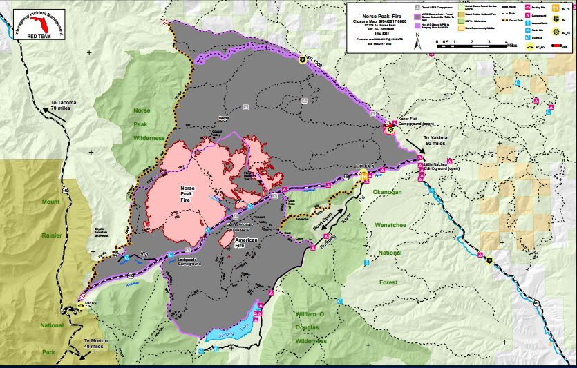
NORSE PEAK FIRE (18,822 acres): Growth occurred on both sides of the Norse Peak fire pushing west over the Pacific Crest Trail and threatening Crystal Mountain Ski resort and nearby communities. To the east, the fire crossed the eastern wilderness boundary north of Hell’s Crossing. Spotting occurred in the southern region of the fire with increased fire activity along State Road 410. Structure protection personnel installed or are working to install hose lays in the summer tract areas and plumb the facilities for sprinklers and will continue working toward the east. Work along 462, 410 and 1900 will continue today.
AMERICAN FIRE (500 acres): The American Fire grew to the south threatening the Bumping Lake area. The southeastern portion of the American Fire crossed Kettle Creek with intense activity, however, south/southeast winds forced the fire back into itself, slowing progress. The fire moved toward Bumping Lake forcing evacuations to residents and visitors. Firefighters will monitor for spots and work ahead of the fire growth as it backs downhill. Structure protection crews will work to plumb structures in Goose Prairie
CLOSURES: In Pierce County, Crystal Mountain Blvd and State Route 410 between mile posts 66 to 69, and in Yakima County, 70 to 89. Area closed is from Chinook Pass to Bumping River Road.
The 1900 or Little Naches Road is closed at the intersection of 1900 and 1902. Kaner Flat and Little Naches campgrounds and the Little Naches Summer Home tract remain open.
Bumping River Road and the trails north of the road are closed to access. Facilities and amenities along the road to the lake such as Goose Prairie, the Bumping Lake Marina, Chinook Outfitters, etc. are closed.
The Pacific Crest Trail is closed from Chinook Pass to Government Meadow.
The latest Forest Closure Order is in place for the fire area and complete details can be found at https://www.fs.usda.gov/alerts/okawen/alerts-notices.
EVACUATIONS: In Yakama County, Little Naches Camp Ground, Naches Cabins and Kaner Flat Campground are at a Level 1 Evacuation. Residents are warned of a potential threat to the area and be prepared for possible evacuations.
All facilities along Bumping River Road and the 1900 Road up to Kaner Flat Campground and the 410 corridor from mile post 69 to 89 are under a Level 3 Evacuation Notice. This means residents are to evacuate immediately. People under Level 3 notifications should evacuate, taking important files, medications, and personal property.
In Pierce County, a Level 3 evacuation has been ordered for the Silver Springs Campground, Silver Creek, Deep Creek, Joke Creek, Alta, Pick Handle and Gold Hill communities and the Crystal Mountain Ski Resort area.
