Everybody knows about Mount Everest and some of us may even dreamed to step up on top of the world. But only few people actually climbed that mountain.
“On the summit day, you feel like you’re really, totally on the edge. If anything goes wrong — it was scarier than I thought it would be.”
–Doctor Tracee Metcalfe
Here is the story. Doctor Tracee Metcalfe works as internist in Vail, Colorado and is affiliated with Vail Valley Medical Center. She has received her medical degree from University of Colorado Denver School of Medicine and has been practicing for more than 10 years. But she is not just a doctor, she is also a mountain climber. She climbed all of Colorado 14-ers and Denali. She has also served as base-camp doctor for multiple expeditions in Nepal. Recently she summited Mt Everest. She also finished 40-mile Elk Mountain Grand Traverse as well as few other backcountry ski races.
Do you want to know how she was preparing for her main accomplishment – Mt Everest summit?
There are several main sections of the way to the top of Mount Everest, and they are all quite challenging and even dangerous. It requires physical strength, ability to navigate on steep slopes around crevasses and ice seracs. Not to mention thin air. So the proper preparation is a part of successful climb.

These are the training tips from Doctor Tracee.
1. Trek to Everest Base Camp (9300 to 17598 feet)
The first section is a trek to Everest Base camp, which is located on a moving glacier, where tents can shift and platforms melt. The area is harsh but beautiful surrounded by Pumori and the Khumbu Icefall with warm mornings and afternoon snow squalls. With so many expedition tents, pathways and generators, it feels like a small village. Starting from Lukla at 2,800 m (9,186 ft), a small town containing an airstrip “Hillary-Tenzing Airport” (the only airport in the region), the trek passes through numerous Sherpa villages and variety of Tibetan influenced monasteries. Although it is the easiest section of the route, it’s still challenging as it is quite long and is passing at the high altitudes up to 17,600 feet.
Is there anything comparable to the trek? Dr Tracee thinks that Colorado Trail is a great option!
The Colorado Trail is Colorado’s premier long distance trail. It stretches 486 miles from Denver to Durango and travels through the spectacular Colorado Rocky Mountains amongst peaks with lakes, creeks and diverse ecosystems. Trail users experience six wilderness areas and eight mountain ranges topping out at 13,271 feet, just below Coney Summit at 13,334 feet. The average elevation is over 10,000 feet and it rises and falls dramatically. Hikers traveling from Denver to Durango will climb 89,354 feet.
— Coloradotrail.org

Large part of the trail goes along the Continental divide trail. It is divided into 28 segments and you can find the detailed information about each segment here. Thru-hiking CT can be a great preparation for 130 km of Everest Base Camp trek, although altitude is lower, but summiting few 14ers and 13ers could be very helpful!
2. The Khumbu Icefall: Everest Base Camp to Camp I (17,598 to 19,685 feet)
Reaching Camp 1 is the most dangerous part of the South Route since it crosses the Khumbu Icefall. The Icefall is 2,000 feet of moving ice, shifting sometimes as much as 3 feet a day. But it is the deep crevasses, towering ice seracs and avalanches off Everest’s West shoulder that creates the most danger.

What could be comparable to the icefall? Yes, it’s Fang, Colorado! The Fang is very popular among climbers during winter months. At this time the waterfall will freeze into a thick ice pole that is 26 foot wide, 165 foot tall. Climbing to the top of the waterfall is very difficult. Here are some tips for climbing the waterfall.

3. Camp I to Camp II (19,685 to 21,000 feet)
The route to Camp 2 comes through a U-shaped valley which is surrounded by Lhotse, Nuptse and Everest. It is also known as “Valley of Silence” , as it is protected from the wind. There are additional crevasse crossings, a combination of large lateral crevasses crossing the route and smaller ones hidden under thin snow bridges, on this broad and rolling glacial snow climb. This is where elevation starts to play a big role in stealing climbers’ breath.

According to Dr Tracee, some of the more challenging traverses between Colorado fourteeners—like winter connectors Little Bear to La Blanca or Mt. Wilson to El Diente—are solid conditioning. Metcalfe also completed the 40-mile winter Elk Mountain Grand Traverse from Crested Butte to Aspen four times.

4. The Lhotse Face: Camp II to Camp III (21,000 to 23,625 feet)
This a steep wall of hard ice, about 30 – 45 degrees. Camp 3 is located halfway up, on a shelf cut into the face.

Dr Tracee suggests the following options – either Dragon’s tail couloir or climbing south of Maroon Bells peaks.
Dragon’s tail couloir is a very steep and dangerous south – south-east facing couloir off Flattop Mountain.
The 1500 ft climb starts gradually and increases in steepness as the couloir narrows towards the top, reaching somewhere around 50 degrees. Depending on conditions, this may be a very classic straightforward snow climb, or you may have to deal with a few rock/icy steps on the way up.
— theoutbound.com

5. Yellow Band and Geneva Spur: Camp III to Camp IV (23,625 to 26,085 feet)
This is the traverse across 40 degree icy slope. There are two rocky features – Yellow Band and Geneva Spur – which climbers should negotiate watching for rock falls. The last part of the section toward Camp 4 is very steep, and once you get there you’re in the Death Zone.
Dr Metcalfe suggest climbing snow and ice walls wearing full Everest footwear. She climbed Silverton mountain as a preparation for that section.

And the last and final section on the way to the summit:
6. South Col: Camp IV to Summit (26,085 to 29,029 feet)
This section involves steep snow climb, exposed ridge as well as rock climb of Hilary Step. The first milestone is the “Balcony” – a flat area on the ridge, then there is a 60 degree rock slab, and the last section is infamous Hilary Step – a 20 meter rock climb at 8700m!
The death zone, in mountaineering, refers to altitudes above a certain point where the amount of oxygen is insufficient to sustain human life.
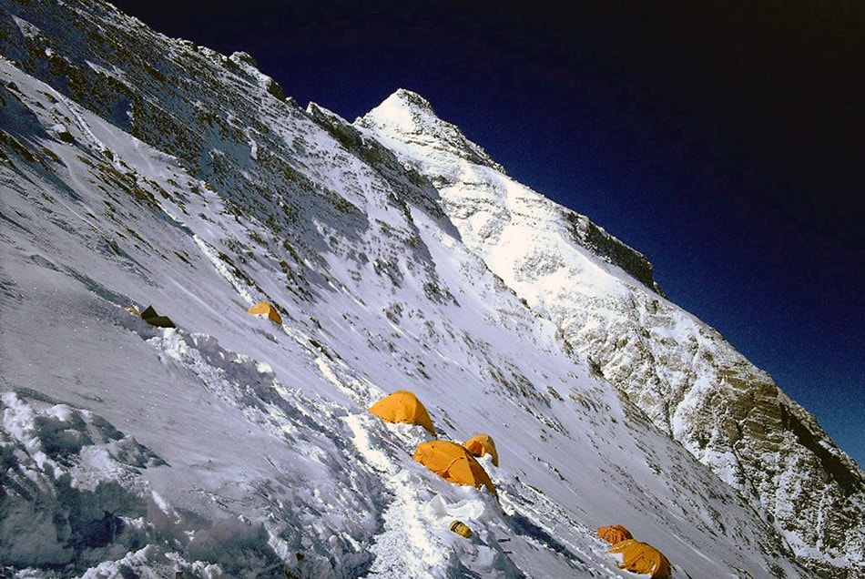
The oxygen level here is only 30% of partial oxygen pressure at sea level. You can’t train your body to accommodate to that altitude. As for physical training the winter connectors Little Bear to La Blanca or Mt. Wilson to El Diente could be a good preparation for the climb in accordance with Dr Tracee.
But remember, climbing the mountain is optional, but descending is mandatory..

