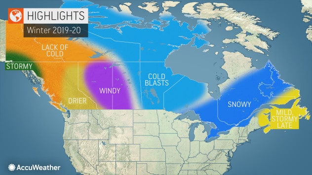
The wait is over. AccuWeather’s annual winter forecast for Canada is out, and our long-range forecasters say Ontario is expected to bear the brunt of stormy weather this season.
Arctic blasts will be focused a bit farther east this year, targeting the eastern Prairies. Also, where could early season snowfall usher in a quick start to the ski season?
- AccuWeather Winter Forecast for the United States: AccuWeather Releases Their Winter 2019/20 Prediction: The Mountains Will Get Snow…
Take a look below at a complete region-by-region breakdown.
British Columbia
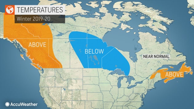
A rather mild winter is anticipated for British Columbia, with the bulk of the season’s Arctic intrusions set to be delivered through central Canada.
“The main storm track will likely bring the bulk of rain and snowfall events to northwestern British Columbia this winter,” AccuWeather’s Canadian Weather Expert Brett Anderson said.
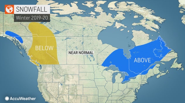
The overall pattern is likely to favor lower snowfall, which would increase the potential for late spring and summer drought next year. Meanwhile, places such as Vancouver, Victoria, Kamloops and Prince George are forecast to be drier and sunnier than usual.
Alberta
The upcoming winter is forecast to be windier than usual, with a higher number of chinook events compared to normal in the southwestern portion of the province.
“This can lead to dramatic swings in temperatures in Calgary and Lethbridge,” Anderson said.
For most of the Province, however, it’s predicted that the bulk of Arctic blasts will be directed farther to the east.
“However, there will certainly be some bitterly cold outbreaks, especially during the first half of the winter,” he added.
The ski season in the Rockies may get off to a quick start, thanks in part to significant early season snowfall. But for the winter as a whole, snow totals for most resorts may end up being below average.

Saskatchewan and Manitoba
The strongest surges of Arctic air are expected to be directed into the eastern half of the Prairies this winter, along with bursts of snowfall from quick-moving storms. This includes cities such as Regina and Winnipeg.
“The majority of these storms will have limited moisture, so I do not expect an unusually snowy winter, but snow that does accumulate may stick around for an extended period of time,” Anderson said.
Come late winter, drier and milder air is predicted.
Ontario
A cold winter is in the cards for northwestern Ontario this year, while farther east, the remainder of the Province looks rather stormy, especially during December and January. The weather pattern has the potential to deliver several significant snowfall events to regions, including the greater Toronto area and into the Ottawa Valley. The main storm track could shift farther east by February, which may lead to less snowfall. However, an increase in spells of very cold air may result in localized lake-effect snow.
Winter sports enthusiasts will enjoy favorable conditions for skiing and snowmobiling. Overall, the winter should feature near-average daytime highs, while nighttime lows will experience above-average temperatures due to increased cloud cover. There is the potential for some significant ice or sleet events across interior southern Ontario, especially during the middle of winter.

Quebec
A snowy winter is anticipated across a large portion of the Province, including Montreal and Quebec City, due to an increased number of moisture-laden storms coming up from the southwest. The bulk of the winter, however, is not forecast to be particularly cold, as the core of the season’s Arctic intrusions will be directed more to the west.
However, there is a chance that the latter part of winter will deliver a cold spell as the storm track shifts more toward the Atlantic coast. Similar to in Ontario, these conditions may spell a good winter for skiers and snowmobilers.
Atlantic Canada
The first half of the winter in Atlantic Canada is forecast to be fairly mild thanks to a persistent southwesterly flow of air. Offshore water temperatures are also expected to run above normal, which may lead to milder air in coastal areas this winter.
Rain or ice may be more likely than snow in places such as Saint John, New Brunswick, Halifax, Nova Scotia, and St. John’s, Newfoundland and Labrador, during the first half of the winter. Though the winter may start out dry, it’s likely to trend stormier during the middle to late part of the season.
“I think the biggest snow events of the season come from late January through early March,” Anderson said.
A colder weather pattern is forecast to set up in the late winter and linger into early spring.