This is the second part of a story about fires in California. Read part 1 here.
Climate change has helped fuel California’s surge of unusually large and destructive fires by exacerbating heat waves and droughts, but climate is not the only factor contributing to the surge. More than a century of fire suppression has caused excessive amounts of dead trees, leaf litter, and dried brush to build up in forests. Meanwhile, California’s increasing population means that many more people now live and work in areas that are prone to fire.
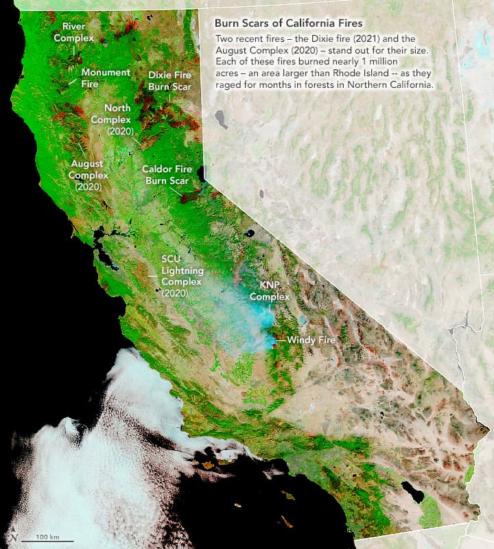
The consequences of all the fires are remarkable, even from space. The false-color image at the top of the page shows burn scars left by large fires that burned in recent years, including the two largest incidents on record in California: the August fire complex and the Dixie fire. The image was captured by the Moderate Resolution Imaging Spectroradiometer (MODIS) on NASA’s Terra satellite on September 21, 2021.
“During the past few years, much of the activity has been in forested parts of the northern two-thirds of California. Many of these forests have built-up a large amount of biomass due to a century of successful fire suppression. Now the bill is coming due.”
– John Abatzoglou, a climate scientist at the University of California, Merced
Before firefighters started intervening and stopping fires in the early 20th Century, low-intensity blazes were periodically ignited by lightning or by Tribal Nations in Northern California. Those fires would periodically burn along the surface and clear out leaf litter, brush, and saplings, thereby reducing the risk of severe fires.
“Low-intensity fires that stay close to the surface don’t cause much ecological damage and can even help forests thrive. But for the better part of a century, we have followed a policy of total fire suppression with few prescribed fires. That has left California with many unnaturally dense and overgrown forest stands.”
– University of California climatologist Daniel Swain
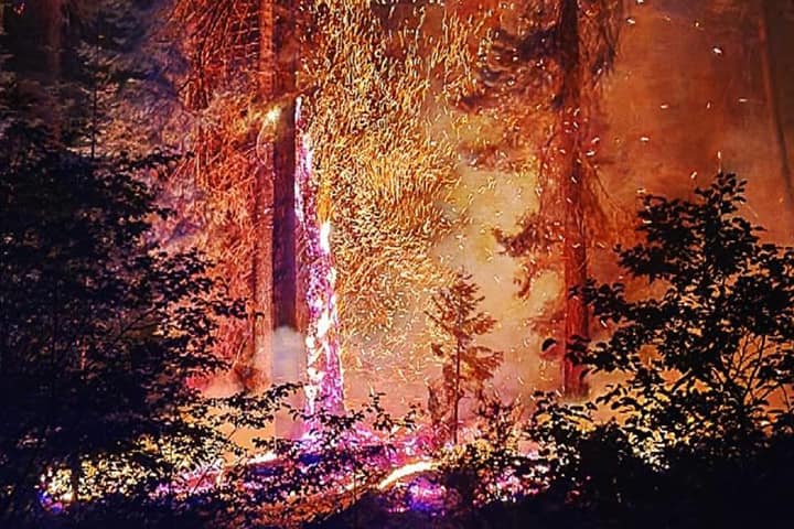
The overabundance of “ladder fuels” makes it much easier for flames to move up tree trunks and turn what might have been low-intensity surface fires into fires that spread along the treetops. These “crown” fires are the hottest, most intense, and most destructive type. “They burn so hot that they consume the majority of the biomass and essentially sterilize the soil,” Swain said. “Unfortunately, there is no list from Cal Fire that neatly lays out the most intense fires, but anecdotally, severe fires seem to be on the rise.”
By some estimates, the accumulation of fuels is at least five times greater than it might have been historically, according to U.S. Geological Survey ecologist Jon Keeley. “When you factor in that California has been in a severe drought since 2012 and has added something like 100 million dead or dying trees to the fuel load, you can see why so many of these fires are so hard to control,” he said.
“The intensity of these extreme fires, combined with the frequency and the proximity to people, is what worries me the most,” said Natasha Stavros, a fire ecologist at the University of Colorado who spent several years doing research at NASA’s Jet Propulsion Laboratory. “Having intense fires frequently means that ecosystems might not have time to recover. In some areas, the ecosystems we know today may be very different than what our children will know.”
Another critical factor for understanding the destructive nature of recent California fires is the expansion of the wildland urban interface (WUI). As California’s population has increased in recent decades, more people have built homes and businesses in and along the edge of fire-prone wildlands. According to one analysis, the number of housing units in the WUI in California increased by a million over a two-decade period—a 34 percent increase. More development in wildlands also means more power lines in fire-prone areas. Power lines and electrical equipment have triggered several incidents on Cal Fire’s list of most destructive fires.
Really large fires are not a completely novel phenomenon in California, according to Keeley. His lab has conducted searches of old newspaper archives, as well as federal and state records, and found massive fires that burned in 1868, 1889, 1891, and 1909. Each probably could be placed among Cal Fire’s top ten largest fires, but the records start in 1919. “But those fires didn’t do much damage to people because they were lower intensity and because there were fewer people and so much less infrastructure around then,” Keeley said.
“It’s the frequency of large fires—and the level of destruction they cause—that has gone up dramatically in recent decades,” he added. “We are now routinely building and living in places where destructive fires are more likely given the fuel loads and what winds are capable of doing.” (Extreme winds make it difficult to protect buildings because of how quickly and widely embers can spread along fire fronts.)
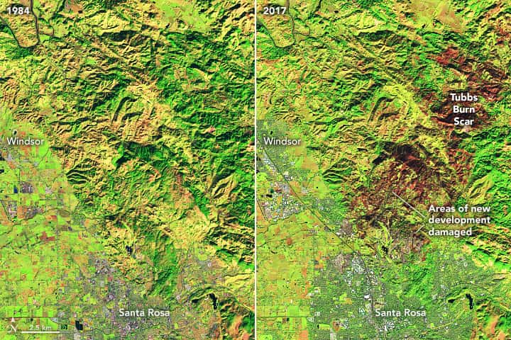
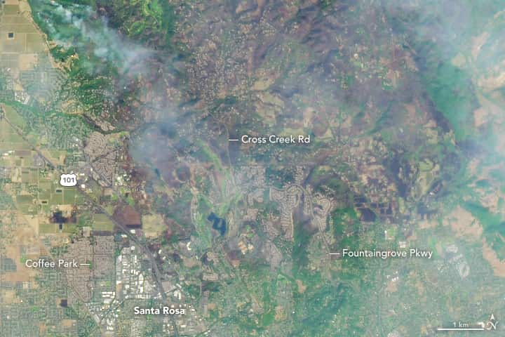
One example of this is the Tubbs fire, which raged through the outskirts of Santa Rosa in October 2017 after being ignited by a spark from an electric power system. Unusually strong winds caused the fire to rapidly push downhill toward Santa Rosa, where it tore through several subdivisions that had recently been built on former forest land. An earlier fire burned roughly the same area in the 1960s but destroyed just a few dozen structures. The 2017 Tubbs fire destroyed more than 5,000 structures because of how much new development had occurred. After the recent fire, charred vegetation and damaged homes were visible in Landsat imagery (above and below).
How we build is also important. “The problem is not just that we are building out into wildlands,” said Stavros. “It’s also that we are not always implementing adequate building codes to protect people and houses—like making sure gutters and vents have ember guards; making sure wooden sheds and barns are not built near homes, or making sure homes have adequate air filters for smoke.”
Population growth and expansion into the WUI is especially important in Southern California, where much of the landscape is chaparral (brush, grass, and small trees). Almost all of the fires there are started by people, not lightning. “They’re typically wind-driven events that spread extremely rapidly,” Keeley explained. “In some circumstances, wind-driven fires are going to spread regardless of what is happening with the climate or in forest management.”
The best way to fight wind-driven fires, Keeley says, is to stop people from starting them and to retrofit infrastructure to minimize risks. That means burying power lines, strictly enforcing fire safety rules during red flag weather, making sure that homes have fire breaks and protection from embers, and keeping communities from being built in fire-prone areas.
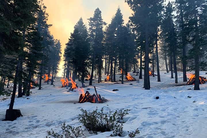
In Northern California, many fire experts think the risks could be reduced significantly by adopting the right regime of forest thinning and prescribed fires during wet weather. “We need more programs that start treating fire as a tool to reduce the incidence of megafires and gigafires,” said Keith Weber, a remote sensing ecologist at Idaho State University and the principal investigator for NASA’s Rehabilitation Capability Convergence for Ecosystem Recovery project. The photograph above shows fires that were set in January 2021 as part of a prescribed fire in Humboldt-Toiyabe National Forest in Nevada. Fires like these can clear away surface fuels that could make future fires more intense.
“We”re not looking at a problem of just fuel accumulation, just population expansion, or just climate change,” said Keeley. “We are facing all three at once, and we’re going to have to find ways to address all of them.”
And it isn’t just California that will be facing this challenge in the coming decades. “There is really nothing unique about California,” cautioned Weber. “The same story could play out pretty much anywhere else across the western United States.”
This article first appeared on NASA Earth Observatory. NASA Earth Observatory images by Joshua Stevens and Lauren Dauphin using Landsat data from the U.S. Geological Survey and MODIS data from NASA EOSDIS LANCE and GIBS/Worldview. Story by Adam Voiland.
Fire/Map nerds, watch these vids:
https://youtu.be/s7FyUlbIfY4
https://youtu.be/eydp4MIG0y8
Don’t forget fire is part of the natural ecology.
WHOOAAAAOOO!!!! Snowbrains is starting to work on solution based reporting instead of just the usual fear mongering reporting.
Cheers guys! If we want to fix problems and make the world a better place we all need to focus our efforts on solutions that are actually going to work and get the results we all want.
I encourage everyone to spend a couple days reading this guys blog. He’s a real deal fire scientist and fire mapper. He points out areas of the dixie fire where the forest was prepared properly and the fire was not so devastating and will actually in the long wrong be a healthy thing.
https://the-lookout.org/
Proper forest management is the key to getting our arms wrapped around the California wild fire problem.