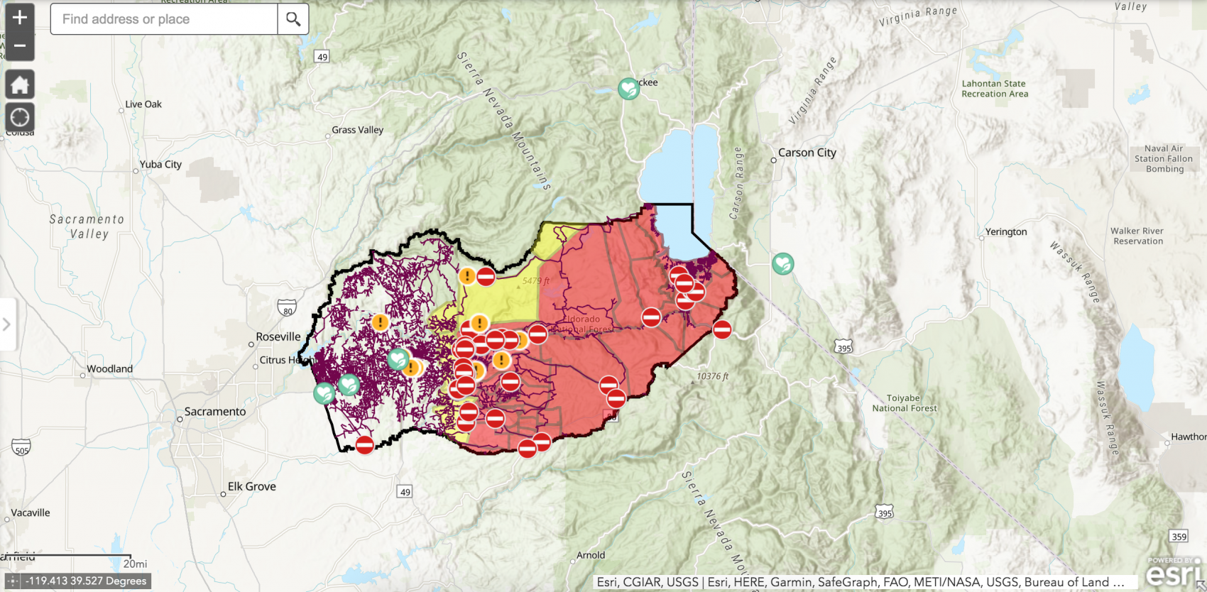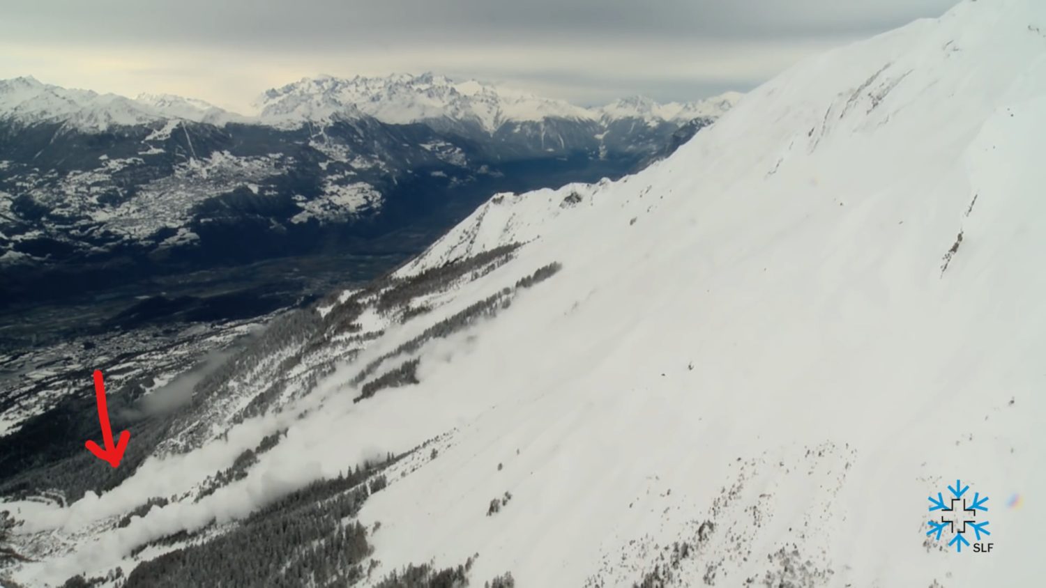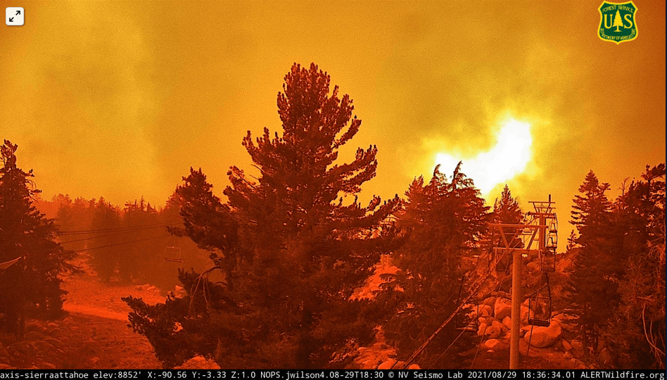
The Caldor Fire reached the Sierra-at-Tahoe ski area yesterday, taking hold in the West Bowl before reaching the mountain’s front side. US Forest Service webcams at the summit of the resort show the fire directly beneath a chairlift.
Early reports this morning are that the resort suffered limited damage, with one structure destroyed.
#CaldorFire (El Dorado Co) – 1 concrete garage type structure burned @ Sierra-at-Tahoe Ski Resort per @JoshEdelson. AA was there doing recon & reported the structures appeared fine/intact in their opinion, including lifts + bldgs @ bottom of slopes. Bit of heat around them tho.
– CA Fire Scanner
Yesterday firefighters were staging at the ski resort, setting down lines and trying to protect structures. The blaze moved more rapidly than anticipated yesterday. Yesterday saw a significant increase in dynamic fire behavior resulting in rapid fire spread. Critical fuel conditions and the alignment of up-slope canyon winds increased extreme fire behavior in the early morning. The afternoon wind speeds produced spotting distances from ¾ to one mile. Active crown fires and group torching were present in multiple areas of the fire, presenting challenging conditions for crews. Additional evacuation warnings and orders were issued in multiples counties late afternoon.
“To put it in perspective, we’ve been seeing about a half-mile of movement on the fire’s perimeter each day for the last couple of weeks, and today, this has already moved at 2.5 miles (4 kilometers) on us, with no sign that it’s starting to slow down.”
– Cal Fire Division Chief Eric Schwab
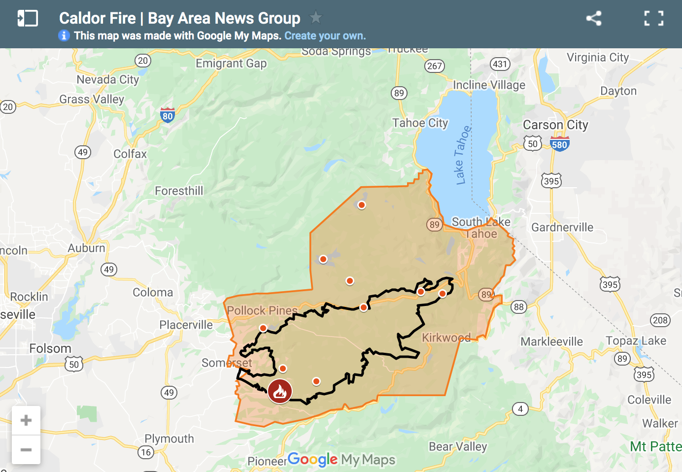
The fire, which began in Eldorado National Forest on August 14th, has burned 168,387-acres and is currently 14% contained. 3,531 personnel are battling the blaze.
As of 9 pm last night, evacuation warnings had been issued for the Lake Tahoe Basin from the Alpine/El Dorado county line, north along the California/Nevada state line to Lake Tahoe, including South Lake Tahoe, and evacuation orders for areas of Alpine County, Amador County, and El Dorado County. Many of those locations are now under a mandatory evacuation order as of this morning, including Kirkwood Mountain Resort.
**New Evacuation Orders and Evacuation Warnings, 8-29-21 at 9:00pm**
There is a detailed map on the attached Cal Fire Press Release. In summary, the entire Desolation Wilderness is now on Evacuation Order and the entire Lake Tahoe Basin is on Evacuation Warning. https://t.co/xsPdfns3c1
— El Dorado Sheriff (@ElDoradoSheriff) August 30, 2021
Last night, police began going door-to-door in South Lake Tahoe to get a head start on evacuating the 20,000 residents and preventing traffic issues if a mandatory evacuation is issued. For residents hoping to leave the Lake Tahoe area and head west toward the Sacramento and Bay Area regions, Interstate 80 is the only option that is still open.
South Lake Tahoe police going to door to door alerting residents to leave. Residents scrambling to pack and get out at 2am. It is still a “warning” but officers are likely not going to come back to announce mandatory orders. #CaldorFire @ABC10 pic.twitter.com/Mvjyecoxlv
— Van Tieu (@Van_Tieu) August 30, 2021
Late Sunday night, the flames moved over Echo Summit and into the Desolation Wilderness, destroying structures atop Echo Summit. To make matters worse, the National Weather Service issued a Red Flag warning for areas including around Lake Tahoe and the Caldor Fire zone, effective from 11 am Monday to 11 pm Tuesday, with strong southwesterly winds and more triple-digit temperatures expected for the region.
The most recent evacuation notices are:
EVACUATION ORDERS:
El Dorado County
- Grizzly Flat: The areas on Grizzly Flats Road east of Kendra Way into Grizzly Flats Proper. The areas of Diamond Railroad Grade, Old School House, Sweeney Road, Caldor Road, and steely Ridge.
- Grizzly Flats Road east of four corners in somerset into Grizzly Flats Proper.
- The areas of Myers Lane, Varmet Ridge Road, Rodwell Canyon Road, Snowbird Lane, and Mehwald Lane.
- East of Sly Park Road between Highway 50 and Mormon Emigrant Trail to Ice House Road. This includes the communities of Pacific House and Fresh Pond.
- North of Highway 50, east of Forebay Road to Ice House Road.
- Intersection of Perry Creek and Hawk Haven, the East side of Fairplay Road from Perry Creek South to Cedarville Road. This includes Slug Gulch, Omo Ranch, and all roads off of Slug Gulch and Omo Ranch.
- All roads off of Omo Ranch from Cedarville Road to Hwy 88.
- The area between Highway 88 and Mormon Emigrant Trail
- South of Highway 50 from Snows Road to Ice House Road.
- Between Highway 50 and Slab Creek from Snows Road to Ice House Road.
- South of Highway 50 from Ice House Road to Silver Fork Road. This includes the community of Kyburz.
- North of Highway 50 from Ice House Road to Silver Fork Road to include Ice House Reservoir, Union Valley Reservoir, and Loon Lake.
- Silver Fork Road in Kyburz east to Twin Bridges.
- North and south in a line extending from Twin Bridges to the Placer County line and south to the Amador County line.
- Areas south of Farnham Ridge Road and east of Bridgeport School Road to the Amador County line.
- From Twin Bridges east to Echo Summit.
- From Highway 50 South to Amador/ Alpine County Line.
- From Highway 50 North to Flag Pole Peak.
- Pleasant Valley Road and all intersecting roads extending south from Newtown Road to the intersection of E-16 (Mt Aukum Road).
- All roads accessed from E-16 (Mt Aukum Road) between Pleasant Valley Road and Bucks Bar Road.
- This includes all roads and residences accessed from Moon-Shadow and Gopher Hole Road off Bucks Bar Road.
- Christmas Valley from Highway 89 West to Echo Summit
- Highway 89 due West to Watershed Ridge/Echo Summit and South to the Amador/El Dorado County line.
- The area from Luther Pass Road, north along the El Dorado/Alpine County line to Armstrong Pass. West from Armstrong Pass to Upper Apache at Meyers. West on Upper Apache to Highway 50. West on Highway 50 to Highway 89. South on Highway 89 to the El Dorado/Alpine County line. This includes all homes on both sides of Highway 89.
- The area from Upper Apache at Meyers, north along Highway 50, to Elks Club Drive. East on Elks Club Drive to Pioneer Trail, extending due south to Upper Apache at Meyers. (This includes all homes off of Oneidas, Mandan, Apache, Ottawa, and Player).
- The area North on Highway 50 from Highway 89 to Saw Mill Road. West on Saw Mill Road to Angora Ridge, extending to the Echo Summit.
- Desolation Wilderness from the watershed ridge to the CA ENF/CA TMU wilderness boundary. From the El Dorado/Placer county line to Echo Lakes.
Amador County
- Highway 89 South from Luther Pass Road to Pickets Junction (Highway 88)
- West on Highway 88 to Kirkwood
- South of Highway 88 along the Amador/El Dorado County line from Dufrene Road, due east to the Amador/Alpine County line and from the Amador/Alpine County line north to Highway 88. This includes the area of Kirkwood Lake.
Alpine County
- Highway 89 south from Luther Pass Road to Pickett’s Junction, (Highway 88) West on Highway 88 to Kirkwood. This includes Kirkwood resort and Caples Lake.
EVACUATION WARNINGS:
El Dorado County
- North of Slab Creek to Wentworth Springs Road between Sand Mountain and Loon Lake.
- Mosquito Road from the bridge North to include the Community of Swansboro.
- North of Highway 50 to Slab Creek between Smith Flat and Snows Road.
- South of Highway 50 to Pleasant Valley between Smith Flat and Snows Road, and North of Pleasant Valley between Holm and Newtown.
- South of Pleasant Valley between Bucks Bar Road and Newtown Road, East of Bucks Bar Road to Kingsbury Drive.
- Southwest of Bucks Bar Road to Ladies Valley Road including the community of Outingdale, Ant Hill Road, Perry Creek Road, and Sand Ridge between Ladies Valley Road and Bucks Bar Road.
- East of Mt Aukum Road (E16) from Bucks Bar Road to Omo Ranch Road. North of Omo Ranch Road to the intersection of Omo Ranch Road and Fairplay Road.
- South of Omo Ranch to the El Dorado County Line between Mt Aukum Road (E16) and Fairplay Road to include Coyoteville Road, Cedar Creek, and all tributary roads.
- From the evacuation order line in Twin Bridges east to the Echo Summit and from Highway 50 south to the Amador and Alpine County lines and north to the Placer County line.
- Dry Lakes Section: This section is north of Wentworth Springs Road up to the Placer County line and the remaining section of El Dorado County south of Placer County to Loon Lake.
- The area from Sawmill Road at Lake Tahoe Blvd. extending north to Pope Beach. Along the water’s edge to Eagle Point. From Eagle Point west to Desolation Wilderness, across Emerald Bay
- The remaining area of the Lake Tahoe Basin. From the Alpine/El Dorado county line, north along the California/Nevada state line to Lake Tahoe. North along the waters edge to the El Dorado/Placer county line. West along the El Dorado/Placer county line to McKinney Lake
Amador County
- Shenandoah Road at the Amador County line west through the River Pines community, continuing west on Shenandoah Road to Ostrom Road.
- South on Ostrom Road to Jibboom Street, West on Jibboom Street to Fiddletown Road.
- East on Fiddletown Road to Hale Road. South on Hale Road to Shake Ridge Road.
- East on Shake Ridge Road to Charleston Road.
- South on Charleston Road to the intersection of Charleston Road and Rams Horn Grade.
- Due east to Highway 88 at Tiger Creek Road.
- Tiger Creek Road east to Salt Springs Reservoir Road.
- East on Salt Springs Reservoir Road to the east end of the Salt Springs Reservoir.
- Due north from the east end of Salt Springs Reservoir to Highway 88.
- South of the El Dorado-Amador County line with a western border of Highway 88 due south to the east end of Salt Springs Reservoir. Northeast border is the line from Dufrene Road east to Amador/Alpine County lines. Southern border of the Amador/Calaveras County line. Eastern border of the Amador/Alpine County line.
Alpine County
- Highway 88 at Forestdale Road. West of Forestdale Road and south to the Pacific Crest Trail Crossing. West of the Pacific Crest Trail to the Summit City Canyon Trail. West of Summit City Canyon Trail and south to the El Dorado / Stanislaus National Forest Line. El Dorado / Stanislaus National Forest Line west to the Alpine and Amador County line.
- South of Armstrong Summit to Woodfords to Forestdale Road, north of Highway 88 and Highway 89 to Armstrong Summit.
EVACUATION SHELTER:
Nevada
- A Red Cross Shelter is open for those evacuating from the area at the Douglas County Community Center, 1329 Waterloo Lane, Gardnerville, NV.
A mandatory evacuation order is defined as an immediate threat to life. This is a lawful order to leave now. The area is lawfully closed to public access.
An evacuation warning is defined as a potential threat to life and/or property. Those who require additional time to evacuate and those with pets and livestock should leave now.
